


27
English
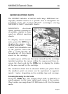
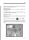
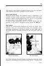
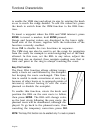
7 - Cursor
Indicates the position expressed in geographical coordinates
(latitude and longitude).
It is displayed when the plotter is in Cursor mode.
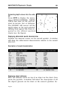
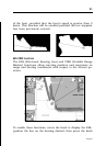
8 - Heading vector
Indicates graphically the boat’s current route.
9 – North indicator
Indicates the north direction when the Chart rotation func-
tion is enabled.
10 – True wind vector
Indicates the direction of true wind detected by onboard in-
struments.
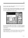
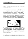
11 – Layline
Indicates the direction after the next tack or gybe. In order to
achieve the best performance, the tack or gybe should be car-
ried out as soon as the layline crosses the target waypoint.