


59
English
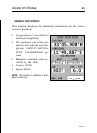
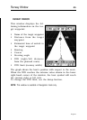
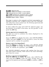
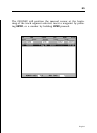
WP NAME: Waypoint name
DISTANCE: Distance from START to current waypoint
TIME: Estimated time from START to current waypoint
FUEL LITERS: Estimated fuel consumption (liters or gallons)
BRG: Bearing from previous waypoint to current waypoint
POSITION: Waypoint latitude / longitude
The time to arrive to the waypoint and fuel consumption are
displayed provided that estimated speed and fuel consump-
tion values have been entered (see the Entering speed and fuel
consumption data Section).
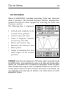
To move within the page and scroll the adjacent pages, use
the joystick. To go back to the menu, use the joystick; to exit,
press the EXIT key.
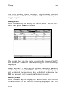
Entering speed and fuel consumption data
The data are used to calculate the values displayed in the
ROUTE window.
Press the GOTO key to display the menu, select ROUTE/SPEED/
CONS. and press ENTER. Use the joystick to enter the data
required and to confirm the operation.
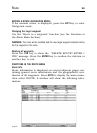
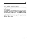
Storing a route in the CompactFlash™
Press the GOTO key to display the menu, select ROUTE, STORE
and press ENTER. To change the default name, use the joy-
stick. To confirm the operation, press ENTER.
The “ROUTE STORED” message will confirm that the route
has been stored correctly. Once stored, the route will disap-
pear from the screen.
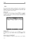
Recalling a route from the CompactFlash™
Press the GOTO key to display the menu, select ROUTE, RE-
CALL and press ENTER to open the route catalog; select the
route by the joystick and then press ENTER to confirm, or EXIT to
exit.