


4
English
INTRODUCTION
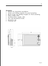
The GEONAV is a chart plotter that can be interfaced with a
GPS receiver, autopilot and other onboard instruments, and
allows displaying the boat’s geographical position with respect
to an electronic chart. Thanks to the GEONAV and a
NAVIONICS Gold™ electronic chart, you will never get lost
even in case of fog, bad weather or dark.
The GEONAV has been designed to allow flush mounting.
Equipped with an easy-to-use keyboard, the GEONAV allows
controlling the autopilot directly from the plotter (Easy Pilot
function) and, thanks to the unlimited capacity of the
CompactFlash™ cartridges - that can also be used on PCs as
personal hard disks - can store a large amount of route, track
and marker data.
The GEONAV is ready for connection with the wind station
and echosounder and, thanks to windows enabled automati-
cally, able to display the relevant data, if available. The con-
nection supports both the NMEA 0183 standard protocol and
the Ethernet Connection system, suitable for the network con-
nection of multiple stations.
The Route functions will allow you to plan a trip, while, thanks
to NAVIONICS Gold™ electronic charts, you will always know
exactly the boat’s position. NAVIONICS Gold™ charts are avail-
able for all the most popular boating areas, provide a large
amount of data - thanks to the object-oriented technology -
and can be used in addition to official paper charts to obtain
additional information such as the availability of port services,
as well as tides and currents data. NAVIONICS Gold™ elec-
tronic charts are available worldwide from authorized
NAVIONICS dealers.
Should new functions be available in the future, it will be
possible to update the GEONAV internal software at any
NAVIONICS dealer.
Introduction