


ix
FOREWORD
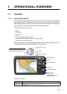
A Word to GP-1670F, GP-1870F Owners
Congratulations on your choice of the FURUNO GP-1670F, GP-1870F GPS Plotter/Sounder. We
are confident you will see why the FURUNO name has become synonymous with quality and re-
liability.
Since 1948, FURUNO Electric Company has enjoyed an enviable reputation for innovative and
dependable marine electronics equipment. This dedication to excellence is furthered by our ex-
tensive global network of agents and dealers.
This equipment is designed and constructed to meet the rigorous demands of the marine environ-
ment. However, no machine can perform its intended function unless operated and maintained
properly. Please carefully read and follow the recommended procedures for operation and main-
tenance.
We would appreciate hearing from you, the end user, about whether we are achieving our purpos-
es.
Thank you for considering and purchasing FURUNO equipment.
Features
The GP-1670F and GP-1870F provide a totally integrated GPS receiver, color video plotter and
color fish finder. The built-in GPS receiver provides highly accurate position, course and speed
information. The fish finder presents vivid underwater images on a high quality LCD. The compact
display unit and antenna unit permit installation where space is limited.
The main features are
General
• Bright 5.7-inch (GP-1670F) or 7-inch (GP-1870F) color LCD with brilliance control.
• Excellent viewing angles, even when wearing sunglasses.
• Internal GPS receiver provides highly accurate position information (GPS, within 2.5 m, SBAS,
within 2 m).
• Customizable analog and digital displays show wind angle and speed, engine condition (speed,
temperature, oil pressure, etc.), etc.
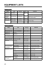
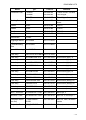
• Large internal memory stores 30,000 track points, 30,000 points, 1,000 routes (500 waypoints/
route).
• SD card slot accepts SD and SDHC cards for external storage of data and settings.
• Full range of alarms: Arrival, Anchor Watch, Cross-track Error, Speed, Depth, Temperature,
Fish Alarm, Bottom Alarm, etc.
• Man overboard (MOB) feature records latitude and longitude coordinates at the time of MOB.
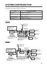
• CAN bus interface for the connection of GPS Receiver, Weather Station, FI-50 (instrument se-
ries), Satellite Compass, etc.
• Accepts NMEA0183 input with optional NMEA data converter.
• Internal GPS antenna available.
• C-Map 4D charts available.