


95
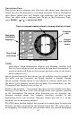
to the destination waypoint. The course line is shown on the Navigation
Page screen (and the Map Page screen) as a line.
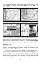
The cross track error range is shown on the compass rose as a wide,
white, corridor enclosing the course line. The outer edges of the white
corridor show the current cross track error range. The default for the
cross track error range is 0.20 miles.
For example, if the present position symbol touches the right cross
track error line, then you are 0.20 miles to the right of the desired
course. You need to steer left to return to the desired course. You can
use the
ZIN or ZOUT keys to change the cross track error range.
A circular symbol depicting your destination (waypoint) appears on the
screen as you approach the waypoint.
Trip Time is the time it will take to reach your destination at your
present closing speed. (You can also customize the time window to show
Arrival Time instead. Arrival Time is the local time it will be when you
arrive at the destination, based upon your present closing speed and
track.)
The Navigation Page has its own menu, which is used for some
advanced functions and for setting various options. (Options and setup
are discussed in Sec. 8.) To access the Navigation Page Menu, from the
Navigation Page, press
MENU.
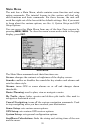
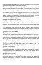
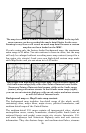
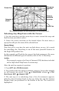
Map Page
The Map Page screens show your course and track from a "bird's-eye"
view. By default, this unit shows the map with north always at the top
of the screen. (This can be changed. See the topic Map Orientation, in
Sec. 8.) If you're navigating to a waypoint, the map also shows your
starting location, present position, course line and destination. You,
however, don't have to navigate to a waypoint to use the map.
Map Page is the default screen that appears when you turn on the unit.
To get to the Map Page from another page: Press
PAGES| → or ← to
MAP|EXIT. When the Map Page is displayed, a screen similar to the
following figure appears.
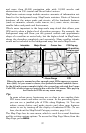
The arrow in the center of the screen is your present position. It points
in the direction you're traveling. The map zoom range is the distance
across the screen. This number shows in the lower right corner. In the
example below, the range is 15 miles from the left edge of the map to
the right edge of the map.
The Zoom In and Zoom Out keys give you control over the zoom range
of the map, allowing you to choose its coverage area and the amount of
mapping detail shown. There are 37 available map zoom ranges, from
0.05 miles to 4,000 miles.