


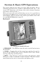
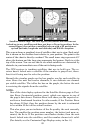


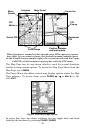
93
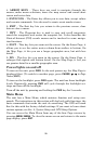
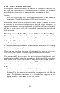
Map Page (left). Map page zoomed to 100 miles (center). Map page
zoomed to 10 miles (right). Over Zoomed means you have reached the
detail limits in an area covered only by the basic background map.
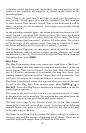
If you are using only the factory-loaded background map, the maximum
zoom range for showing additional map detail is 15 miles. You can con-
tinue to zoom in closer, but the map will be enlarged without revealing
more map content (except for a few major city streets.) Load your own
high-detail custom map made with MapCreate (or a pre-made Free-
domMap from LEI), and you can zoom in to 0.02 miles with massive
amounts of accurate map detail.
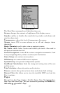
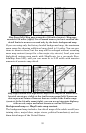
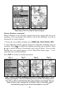
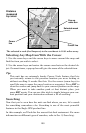
Map Pages loaded with high-detail MapCreate map of an urban area.
Arterial streets are visible at the 4-mile zoom range (left). Numerous
dots represent Points of Interest that are visible at the 2-mile range.
(center). At the 0.4-mile zoom (right), you can see an interstate highway
with an exit, major and minor streets as well as POI icons.
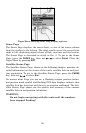
Background map vs. MapCreate map content
The background map includes: low-detail maps of the whole world (con-
taining cities, major lakes, major rivers, political boundaries); and me-
dium-detail maps of the United States.