


94
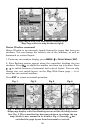
The medium-detail U.S. maps contain: all incorporated cities; shaded
metropolitan areas; county boundaries; shaded public lands (such as
national forests and parks); some major city streets; Interstate, U.S.
and state highways; Interstate highway exits and exit services informa-
tion; large- and medium-sized lakes and streams; and more than 60,000
navigation aids and 10,000 wrecks and obstructions in U.S. coastal and
Great Lakes waters
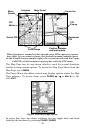
MapCreate custom maps include massive amounts of information not
found in the background map. MapCreate maps contain the searchable
Points of Interest database, all the minor roads and streets, all the
landmark features (summits, schools, radio towers, etc.) and smaller
lakes, rivers, streams, and ponds.
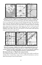
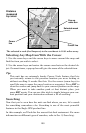
What's more important is the large scale map detail that allows your
GPS unit to show a higher level of position accuracy. For example, the
background map would show you the general outline and approximate
shape of a coastline or body of water, but the higher detail in MapCre-
ate shows the shoreline completely and accurately. Many smaller is-
lands would not be included in the background map, but are in Map-
Create.
NOTE:
Available through LEI Extras (look inside back cover for accessory
ordering information), FreedomMaps are pre-made maps that con-
tain all of the same information available in a custom MapCreate
map.
Tip:
In some urban areas, businesses are so close to one another that
their POI icons crowd each other on the screen. You can reduce
screen clutter and make streets and other map features easier to
see by turning off the display of POIs you're not watching for. (To
see how, check the text on Map Detail Category Selection, page 142.
It shows how to use the Map Categories Drawn menu to turn indi-
vidual POI displays off and on.) Even though their display is turned
off, you can still search for POIs and their icons will pop-up when
your unit finds them for you.