


108
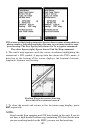
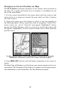
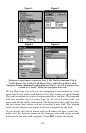
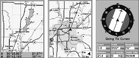
The 30-mile zoom figure (left) clearly shows the red course line connecting
your current position to your destination. The second figure (center)
shows current position and direction to the destination. The Navigation
Page (right) will also show navigation information.
To stop navigating to the cursor, use the Cancel Navigation command:
press
MENU|MENU|↓ to CANCEL NAVIGATION|ENT|← to YES|ENT. The unit
stops showing navigation information.
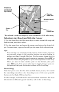
Navigate to a Point of Interest
For POIs that are in view on the map, you can easily use the Navigate
to Cursor command above; just use the cursor to select the POI.
The other method involves searching for POIs with the Find Waypoint
command, launched with the
WPT key. (See the searching example ear-
lier in this section or turn to Sec. 9, Searching, for detailed instructions
on POI searches.)
After you have looked up an item with the Find Waypoint command,
use ← → to make sure the
GO TO command is highlighted at the bottom
of the screen, then press
ENT. The unit shows navigation information to
the item.
To cancel navigation, press
MENU|MENU|↓ to CANCEL NAVIGATION|ENT|←
to
YES|ENT. The unit stops showing navigation information.
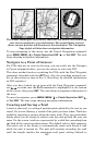
Creating and Saving a Trail
A trail, or plot trail, is a string of position points plotted by the unit as you
travel. It's a travel history, a record of the path you have taken. Trails are
useful for repeating a journey along the same track. They are particularly
handy when you are trying to retrace your trip and go back the way you
came. On the screen, trails are represented by a solid line extending from
the back of the current position arrow. The default color is light magenta.
The unit is set at the factory to automatically create and record a trail
while the unit is turned on. The unit will continue recording the trail
until the length reaches the maximum trail point setting (default is