


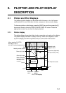
2. PLOTTER AND PILOT DISPLAY DESCRIPTION
2-4
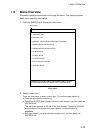
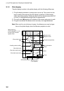
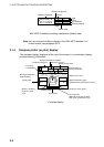
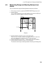
TRKS 00M01s
2003. 4. 13
34 44.1447'N
135 21.0758'E
Latitude, longitude
Speed over ground
Trip distance
Date
Time
Course
SOG 9.9kt
COG 350.2 T
DPT 16.2 m
TEMP 5.3 C
00:01
TRIP 0nm
Depth
Water temp.
Tracking interval
NAV INFO 2 window on setting a destination (default data)
Note: You can choose the data to display in the NAV. INFO windows. For
further details, see paragraph 9.6.2.
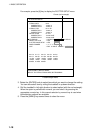
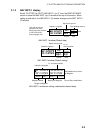
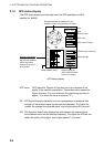
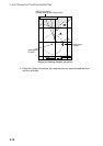
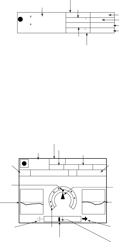
2.1.4 Compass plotter (or pilot) display
The compass display, displayed at the top of the screen in a combination display,
provides steering information.
Bearing scale
XTE monitor
Depth graph
Time-to-go
to destination
Ship's course (red)
Destination waypoint
Range to destination waypoint
Speed over ground
Bearing to destination
waypoint (black)
5
25
10
0
BRG TO WPT
DEPTH
TEMP
359.9˚M
14. 9 m
0D 9H 59M
TTG
1st 23 : 59
ETA
SOG
9. 9
kt
STW
RANGE
0.43 nm
N
E
Speed through water
COG
Direction to steer (green)
Shown in red when
direction to steer
is left.
Own ship mark
(Black when the ship is within
XTE range, yellow when over.)
000001
10. 5
kt
4. 9˚C
w
359.9˚M
Estimated time of
arrival at destination
Water temperature graph
(Required water temperature sensor.)
Compass display