


4. MARKS & LINES
4-10
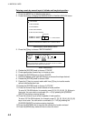
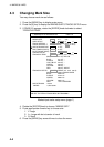
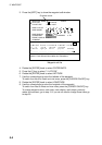
4.8 Displaying Mark Data
You can display mark data as follows;
Note: Files set to “YES” on the DISPLAY DATA FROM MEMORY CARD menu
cannot be displayed. (See paragraph 10.2.3.)
Also, files set to “YES” on the DISPLAY DATA FROM INTERNAL
MEMORY menu cannot be displayed. (See paragraph 10.4.2.)
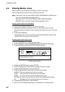
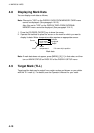
1. Press the [CURSOR ON/OFF] key to show the cursor.
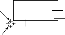
2. Operate the trackball to place the cursor on the mark for which you want to
display its data. Water temperature data requires an appropriate sensor.
37˚04.640'N
135˚21.047'E
+ 4.5˚C 13.7m
Mark
Cursor
Water
temperature*
Depth*
Latitude
Longitude
*: For own ship's position
Mark data
Note: If mark data does not appear, press [MENU], [0], [1] in that order, and then
turn on MARK STATUS on PAGE 2/2 of the DISPLAY SETUP menu.
4.9 Target Mark (TLL)
Target position data can be output from certain radars and shown on your plotter
with the TLL mark (x). For details, see the Operator’s Manual for your radar.