


8 LAYOUT
8-4
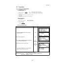
8.1.2 Selecting Coordinate Data File
You can execute a Layout from selected coordinate data file, also you can record New point measured
data into the selected coordinate data file.
● The only coordinate data file existing can be selected and you can not make a new file in this mode.
For more information about File, refer to Chapter 9 “MEMORY MANAGER MODE”.
● When LAYOUT MODE is begun, a file can be selected in the same way.
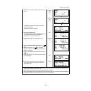
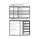
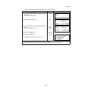
Operating procedure Operation Display
1 Press the [F1](SELECT A FILE) key from the
Layout menu 2/2.
[F1]
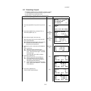
2 Press the [F2](LIST) key to display the list of
coordinate data file.*1)
[F2]
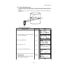
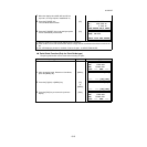
3 Scroll file list by pressing the [ ]or[ ] key and
select a file to use. *2),3)
[ ]or[ ]
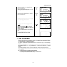
4 Press the [F4](ENTER) key.
The file will be set .
[F4]
*1) If you want to input file name directly, press the [F1](INPUT) key and enter a file name.
*2) When a file has been selected already, ‘*’ mark is indicated on left of current file name.
For the file discrimination mark (*, @, &), refer to Section 9.3 “FILE MAINTENANCE”.
*3) Data in a file shown with arrow can be searched by pressing the [F2](SRCH) key.
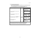
LAYOUT 2/2
F1:SELECT A FILE
F2:NEW POINT
F3:GRID FACTOR P
↓
SELECT A FILE
FN:
INPUT LIST ––– ENTER
COORDDATA /C0123
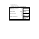
→
*TOKBDATA /C0345
TOPCDATA /C0789
––– SRCH ––– ENTER
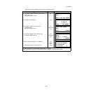
*TOKBDATA /C0345
→
TOPCDATA /C0789
SATIDATA /C0456
––– SRCH ––– ENTER
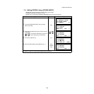
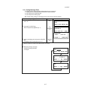
LAYOUT 2/2
F1:SELECT A FILE
F2:NEW POINT
F3:GRID FACTOR P
↓