


5-1
5. RADAR MAP AND TRACK
5.1 What is a Radar Map?
A radar map is a layer consisting of marks and lines overlaid on the radar display. A
map is intended for indicating safety-related areas and objects. Ten radar maps can
be made and each map can have a total of 4,000 lines and marks. The map data can
be saved to facilitate repeated use on a routine navigation area. The user can create
a radar map on-real time while using the radar for navigation or at leisure time at an-
chor or while the radar is not being used. Waypoints, events and user charts from the
chart can be shown or hidden on the radar map display.
The radar map does not affect any radar function.
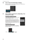
5.2 Presentation Modes
Five presentation modes are available: North-up, Course-up, Head-up, Head-up TB
(True Bearing), Stern-up and North-up TM. To select a mode, use the MODE key on
the Control Unit or click the [Range/Presentation mode] box.
Note: Chart data is not displayed in the head-up and head-up TB modes.
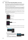
5.3 How to Show, Hide the Radar Map Display
Click the [MAP ON/OFF] button to display [MAP ON] or [MAP OFF] as appropriate.
[MAP ON/OFF]
button