


11-1
11. CHART ALERTS
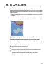
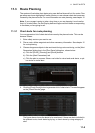
The chart radar can detect areas where the depth is less than the safety contour or
detect an area where a specified condition exists. If prediction of own ship movement
goes across a safety contour or an area where a specified condition exists, the system
does the following:
• Highlights warning alert objects in red (route checked in route planning, and route
navigation)
• Provides visual alerts in the [Alert] box for warning alert objects (route navigation)
• Sounds an aural alarm for warning alert objects (route navigation)
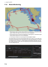
For this function, the chart radar utilizes the chart database (S57 charts) stored on the
SSD in SENC format. Note that the chart radar calculates dangerous areas using
the largest scale chart available, which may not be the visualized chart.
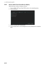
You can choose objects that are included for calculation of danger area (for example,
restricted areas). A dialog box lists the various areas that activate danger warnings.
You can also define your own safe area by creating a user chart area. The system can
utilize these areas when calculating chart alerts.
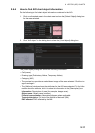
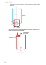
z The ECDIS can check the following for you:
• Predicted movement area of own ship
• Planned route with an easy to use locator function to find dangerous areas
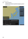
z The ECDIS will highlight the following for you
• Dangerous areas inside predicted movement area of the own ship
• Dangerous areas inside your monitored route
• Dangerous areas inside your planned route
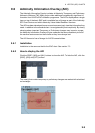
Warning alert (highlight)