


14. HOW TO MONITOR ROUTES
14-4
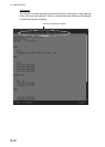
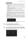
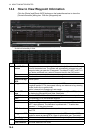
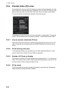
14.4 How to View Waypoint Information
Click the [Route] and [Route INFO] buttons on the InstantAccess bar to show the
[Route Information] dialog box. Click the [Waypoints] tab.
No. Item Description
1 To WPT, GO
button
The system chooses a next waypoint automatically. Check that the To way-
point is the desired one. The system will automatically advance to a next
waypoint when you pass the To waypoint. The default To WPT is WPT1. If
you desire a different one, select it here and the click the [GO] button.
Distance Distance from current position to selected waypoint.
Departure The time the route was selected for monitoring.
Actual Average
SPD
Actual speed
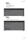
2 Waypoint list The waypoint list provides for each waypoint WPT no., name, latitude and
longitude position, ETA, plan speed, bearing and distance to leg, steering
mode (rhumb line or great circle),
radius, channel limit, speed max, and margin.
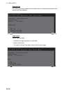
3 Check ETA win-
dow
Parameters for checking ETA. The arrow to the left of [Check ETA] collapse
or display the [Waypoints] and [User Chart] tabs.
WPT, Distance Select a WPT to find the distance to that waypoint from current position.
Plan The planned ETA to the selected waypoint.
Actual The actual ETA to the selected waypoint.
Off Plan The time difference between planned ETA and calculated ETA to final
WPT, when different. The indication is prefixed with "-" if earlier than
planned; "+" if later than planned.
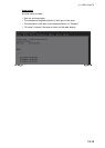
SPD Calculate Enter speed and ETA (time and date) to find the speed to use to arrive by
the ETA.
Suggested SPD The system calculates suggested speed so that ETA to the final WPT
would be same as planned ETA if type of optimization was "Time table"..
Start Calculate Click to start calculation. The button label changes to [Stop Calculate].
4 Total WPTs The total number of waypoints in the route.
Total Distance The total distance of the route.
*
* Scroll list horizontally to view