


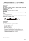

APPENDIX 3 DIGITAL INTERFACE
AP-25
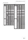
GGA - Global positioning system fix data
GLL - Geographic position, latitude/longitude
GNS - GNSS fix data
$**DTM,ccc,a,x.x,a,x.x,a,x.x,ccc,*hh<CR><LF>
1 2 3 4 5 6 7 8
1. Local datum (W84=WGS84 W72=WGS72 S85=SGS85, P90=PE90
2. Local datum subdivision code (NULL or one character)
3. Lat offset, min (0 - 59.99999)
4. N/S
5. Lon offset, min (0 - 59.99999)
6. E/W
7. Altitude offset, meters (No use)
8. Reference datum (W84=WGS84 W72=WGS72 S85=SGS85, P90=PE90)
$**GGA,hhmmss.ss,llll.lll,a,yyyyy.yyy,a,x,xx,x.x,x.x,M,x.x,M,x.x,xxxx,*hh<CR><LF>
1 2 3 4 5 6 7 8 9 10 11 12 13 14
1. UTC of position (no use)
2. Latitude (0000.00000 - 9000.00000)
3. N/S
4. Longitude (0000.00000 - 18000.00000)
5. E/W
6. GPS quality indicator (1 - 8)
7. Number of satllite in use (No use)
8. Horizontal dilution of precision (0.0 - 999.9)
9. Antenna altitude above/below mean sealevel (No use)
10. Unit, m (No use)
11. Geoidal separation (No use)
12. Unit, m (No use)
13. Age of differential GPS data (0 - 999)
14. Differential reference station ID (No use)
$**GLL,llll.lll,a,yyyyy.yyy,a,hhmmss.ss,a,x,*hh<CR><LF>
1 2 3 4 5 6 7
1. Latitude (0000.00000 - 9000.00000)
2. N/S
3. Longitude (0000.00000 - 18000.00000)
4. E/W
5. UTC of position (No use)
6. Status (A=data valid V=data invalid)
7. Mode indicator (A=Autonomous D=Differential E=Estimated M=Manual input S=Simulator)