


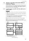

1. INTRODUCTION
1-8
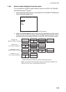
Available displays
The table below shows all the nav data and graphic displays available. Appropriate
sensors are required.
*
1
Can not be selected in case of Fantum Feedback
TM
.
*
2
Any mode other than WIND.
For Fantum Feedback
TM
, NAVpilot-711 and NAVpilot-720 can not display
[DEVIATION].
*
3
WIND mode only
Data displayed Data meaning
Nav data displays
AIR TEMP Air temperature
ATMOS PRESS Atmospheric pressure
BRG Bearing to waypoint
COG Course over ground
DATE Current date
DEWPOINT Dewpoint
DPT Depth
ETA Estimated time of arrival to waypoint
HUMIDITY Humidity
POS Position
RNG Range to waypoint
SOG Speed over ground
STW Speed through water
TEMP Water temperature
TIME Current time
TRIP Trip distance
TTG Time-to-go to waypoint
VOLT Input/output voltage to processor unit
WIND APPARENT Apparent wind direction/speed
WIND TRUE True wind direction/speed
WPT Waypoint position (Latitude/Longitude)
XTE Cross-track error
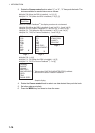
Graphic displays
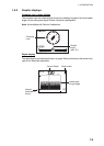
COMPASS, RUDDER*
1
Compass rose, and analog and digital rudder angle
DEPTH Analog and digital depth
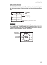
ENGINE SPEED Analog engine speed (revolution meter)
HIGHWAY Graphic presentation of progress towards waypoint
RUDDER*
1
Analog and digital rudder angle
TEMP Analog (graph) and digital water temperature
WIND APPARENT Analog and digital apparent wind direction speed
WIND TRUE Analog and digital true wind direction speed
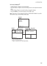
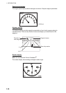
Rudder angle, deviation, wind deviation (analog)
RUDDER*
1
Rudder angle
DEVIATION*
2
Heading deviation:
WIND DEV.*
3
Wind deviation