


8
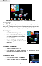
Getting Started
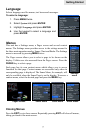
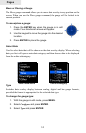
Selecting Chart Data
This unit supports Lowrance and Navionics map
data. Chart data is selected from the Chart Settings
menu.
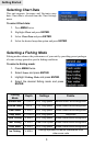
To select Chart data:
1. Press MENU twice.
2. Highlight Chart and press ENTER.
3. Select Chart Data and press ENTER.
4. Select the desired map data option and press ENTER.
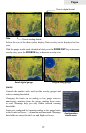
Selecting a Fishing Mode
Fishing modes enhance the performance of your unit by providing preset packages
of sonar settings geared to specic shing conditions.
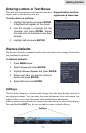
To select a shing mode:
1. Press MENU twice.
2. Select Sonar and press ENTER.
3. Highlight Fishing Mode and press ENTER.
4. Select the desired shing mode and press
ENTER.
Fishing
Mode
Depth Settings Palette
General Use ≤1,000 ft 50% Ping speed Bottom brown/ blue background
Shallow Water ≤ 60 ft 75% Ping speed bottom brown/white background
Fresh Water ≤ 400 ft 50% Ping speed bottom brown/white background
Deep Water ≥ 1,000 ft 50% Ping speed Deep Blue
Slow Trolling ≤ 400 ft 50% Ping speed Bottom brown/white background
Fast Trolling ≤ 400 ft Lower chart speed Bottom brown/white background
Clear Water ≤ 400 ft 50% Ping speed Bottom brown/white background
Ice Fishing ≤ 400 ft
Settings optimized to reduce interference from
other sonar units