


38
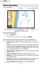
Chart
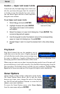
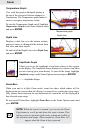
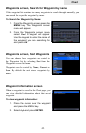
To access the Chart page:
1. Press the PAGES key.
2. Use the keypad to select the Chart icon and press ENTER.
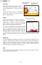
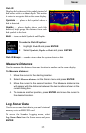
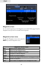
The previous image shows items you will see on the chart page:
• Point of Interest (POI): A position represented by a symbol or
character.
• Cursor: Used to view specic areas on the Chart page, select POIs,
create waypoints and measure distances. When the cursor is on-
screen, pressing the EXIT key will toggle between the cursor's loca-
tion on the Chart page and your actual position.
• Chart orientation indicator: Indicates the current direction the Chart
page is facing.
• Cursor coordinates: Displays the coordinates of the cursor.
• Waypoint: An electronic address based on the latitude and longitude
of a selected location.
• Map Scale: Represents the relationship between the distance on
the Chart page and the real distance on the earth's surface.
• Current position icon: Represents your current position.
Chart Operation
Point of Interest (POI)
Cursor coordinates
Waypoint
Map scale
Cursor
Current position icon
Chart orientation indicator
Chart page in 2D Chart mode