


1-1
C
C
C
h
h
h
a
a
a
p
p
p
t
t
t
e
e
e
r
r
r
1
1
1
I
I
I
n
n
n
t
t
t
r
r
r
o
o
o
d
d
d
u
u
u
c
c
c
t
t
t
i
i
i
o
o
o
n
n
n
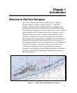
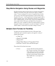
Welcome to RayTech Navigator
This User’s Guide describes how to use Raymarine
®
’s RayTech
Navigator marine navigation software (Figure 1-1). RayTech
Navigator operates within a standard Windows
®
environment, and
enables you to utilize the latest digital charts and Global Positioning
System (GPS) instrumentation to help you pilot your vessel to virtually
anywhere in the world. Navigator easily interfaces with your boat’s
onboard navigational systems, offering you the flexibility to allow
Navigator to autopilot your vessel to any destination you choose to
plot. Navigator also incorporates the capability to download the latest
weather and oceanographic information and display it on any chart,
thus keeping you apprised of foul weather near you or your destination.
Furthermore, Navigator is the perfect choice for the serious sailor
or fisherman, offering advanced optional modules that enhance
Navigator’s route-plotting and fish-finding performance. The subsec-
tions that follow detail the sophisticated capabilities and features of
RayTech Navigator.
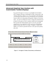
Figure 1-1. Typical RayTech Navigator Chart Screen