


4-1
C
C
C
h
h
h
a
a
a
p
p
p
t
t
t
e
e
e
r
r
r
4
4
4
W
W
W
o
o
o
r
r
r
k
k
k
i
i
i
n
n
n
g
g
g
W
W
W
i
i
i
t
t
t
h
h
h
C
C
C
h
h
h
a
a
a
r
r
r
t
t
t
s
s
s
A
A
A
n
n
n
d
d
d
R
R
R
o
o
o
u
u
u
t
t
t
e
e
e
s
s
s
Overview
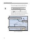
This chapter explains how to use RayTech Navigator to chart and
plot courses for nautical navigation. The chapter is intended to
have you navigating with the basics in the shortest possible time,
and leaves the more complex Navigator operations for Chapter 5,
“Advanced Navigator Functions.” Refer to that chapter if you
already have a working knowledge of Navigator. This chapter
covers the following areas:
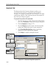
• Installing, displaying, and manipulating the various chart types
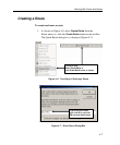
• Creating, editing, and implementing waypoints and routes
• Getting and using the latest weather and oceanographic reports
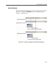
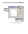
Installing Charts
This section explains how to install and load the various chart types
that Navigator uses.
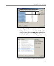
About Using Charts with Navigator
Navigator supports all of the popular chart types, including:
• C-Map NT
• Maptech NOAA/BSB
• Maptech PCX
• Maptech Photo Regions and Topographical Charts
• SoftCharts Nautical Charts and PhotoNavigator
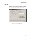
Important: Navigator automatically loads a default World Chart
on each start-up. You cannot close this window or uninstall this
chart — simply open a new window over it.