


5-1
C
C
C
h
h
h
a
a
a
p
p
p
t
t
t
e
e
e
r
r
r
5
5
5
A
A
A
d
d
d
v
v
v
a
a
a
n
n
n
c
c
c
e
e
e
d
d
d
N
N
N
a
a
a
v
v
v
i
i
i
g
g
g
a
a
a
t
t
t
o
o
o
r
r
r
F
F
F
u
u
u
n
n
n
c
c
c
t
t
t
i
i
i
o
o
o
n
n
n
s
s
s
Overview
This chapter covers the more advanced Navigator functions such as
Radar and Sonar. It also includes information about using Polars
data and graphics to analyze and fine-tune your racing sailboat’s
performance.
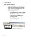
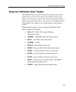
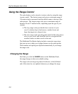
Using Radar With Navigator
This sections explains how to use the various Radar functions within
Navigator. Data from your hsb
2
Series Pathfinder Radar can be
transferred and displayed (repeated) in a Navigator. The radar
output can be displayed in a separate window or overlaid on a chart.
Connection is made from the hsb
2
connection via a special cable that
inputs to a PCMCIA card in your PC
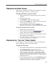
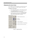
When a scanner is connected and the radar is in Transmit mode, the
radar picture provides a map-like representation of the area in which
the radar is operating. Typically, your ship’s position is at the center
of the display, and its dead ahead bearing is indicated by a vertical
heading line, known as the Ship’s Heading Marker (SHM).
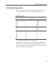
The radar picture can be viewed with a variety of fixed or customized
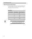
range scales. The color of the radar returns (echoes) indicates their
intensity: the strongest returns are shown in yellow and the weaker
are shown in shades of blue. A status bar at the top of the radar image
displays range, current heading and mode indicators for the various
options you can set.
The radar display can show additional information, depending on
your currently selected options, set up selections and the data available
from other equipment. The example displays on the following pages
show some of these features.