


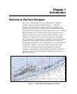

Introduction
1-5
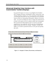
Integrates with Raymarine’s SeaTalk
®
and NMEA 0183
Data Output Devices
Navigator is designed to work transparently with Raymarine’s SeaTalk
data communications package, or any other device that outputs data
in NMEA 0183 format. This enables parameters such as Heading,
Wind Speed/Direction, Sea Temperature, and a variety of others to be
accessed and displayed within Navigator. Navigator can also connect
to such onboard systems as Ockam, B&G, and KVH via a standard
RS-232 data cable. This enables the information collected by
Navigator to be relayed and displayed on your vessel’s standard
onboard instrumentation systems.
Navigator also connects to Radar systems that are capable of
outputting Cursor Range and Bearing, and also to ARPA Radar
systems. This allows targets identified by Radar to be plotted on
directly onto Navigator’s chart displays. You can also connect
Navigator to a variety of proprietary instruments, and generate
comprehensive log files which can then be analyzed from within
Navigator or saved and exported for future external analysis.
3-D Contour Display
Navigator’s advanced 3-D Contour Display shows your vessel, the
ocean floor, and other related information using a 3-D vector-style
display. This enables you to view any area, such as favored fishing
and sailing spots, harbor entrances, and so forth, within a full, 3-
dimensional window. Images can be rotated 360° so you can view
your vessel’s position from virtually an angle. 3-D Contour gives you
useful navigational perspectives that you might not be able to ascertain
from a conventional display.
The 3-D Contour Display includes:
• Past navigational markers
• Depth markers
• Transducer cone images