


GPS Chart Plotters Page 27
3. CONTROLS AND INDICATORS
NOTE
This section defines each control of the GPS Chart Plotter. For instructions, refer to Getting Started
and Advanced Settings sections of this Owner's Manual.
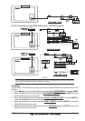
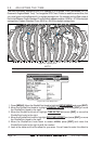
3.0 CONTROLS AND CONNECTIONS
The GPS Chart Plotter is controlled by using the keys located on the front panel. These labelled
keys are dedicated to specific functions. As you press a key, a single audio beep confirms the
key action; every time a key press is not valid, three rapid beeps sound to indicate that the key
action is not valid. There is also a ShuttlePoint knob to move the cursor across the screen.
The ZOOM IN and ZOOM OUT keys
Pressing [ZOOM IN] shows more detail of a smaller area, by changing the chart scale and
zooming in on your display. Press [ZOOM OUT] to change the scale and show a wider,
otherwise less detailed view. Pressing and holding [ZOOM IN]/[ZOOM OUT] allows for
quick zoom, that is the fast change of the chart scale where only the land areas are drawn.
When [ZOOM IN]/[ZOOM OUT] is released all map details are shown.
NOTE
The GPS Chart Plotter contains a Worldwide background that allows you to zoom into 2NM. For
more detail, a C-MAP NT
+
/MAX C-CARD must be purchased and installed.
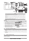
The ShuttlePoint knob
The ShuttlePoint knob moves the cursor about on the display screen, quickly and accurately.
It also scrolls the desired option in the menu page(s). It changes the Chart Plotter from Home
Mode to Cursor Mode on the Chart Screen. For a detailed explanation of Cursor VS Home
mode refer to section 3.1.1.
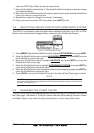
The ENT key
Press [ENT] to select the desired option or to confirm selection.
The CLR key
Press [CLR] to set Home mode. Also press [CLR] to exit from menu or data windows or to
leave a menu without making changes, to abort selected function or to step backward from
a selection made in the menu.
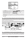
The MENU key
Selects the Main Menu. When in the Setup Menu mode, moving the ShuttlePoint knob to
the right enters a selection, moving the knob to the left clears the function.
Press and hold [MENU] for 3 seconds allows you to change the fields contained within the data
windows while on the Chart, Navigation, Highway, GPS Status or NMEA Display Page.
Press and hold [MENU] for 3 seconds from Navigation, Highway, GPS Status, NMEA and
Chart pages allows the data fields to be customize.
The GOTO key
This key is very useful when you desire to start navigating (goto) to a destination point. When
pressed, a popup window will be shown allowing you to select to start navigating to the
position of the cursor, Mark or Route.