


CP500 Page 55
10. TRACKS
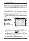
The GPS Chart Plotter has the capability to store 5 individual tracks and record up to 3000
Track Points.
Before using the Track function you will need to setup the Track function that suits your boat.
The Track function tracks your vessels location as it moves through the water. The Track
function can be setup to lay down a Track for a predetermined time or distance interval. If
you have a fast moving boat you may want to setup the GPS Chart Plotter to record a Track
point every 0.5NM or if you have a sail boat you may want to setup to lay down a Track point
once ever 1 minute.
NOTE
Please note the Track point memory is 3000 points. This means for a long journey you may have to
adjust the time or distance to be able to track your journey. It should be noted when the 3000 Track
points are used up, the first Track point layed down will be deleted when a new point is placed on the
chart.
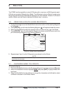
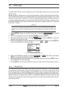
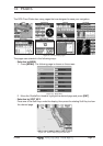
1. Press [MENU]. Move the ShuttlePoint knob to highlight USER POINTS and press
[ENT].
2. Move the ShuttlePoint knob to highlight
TRACK and press [ENT].
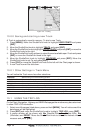
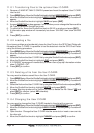
3. Move the ShuttlePoint knob to highlight
STEP UNIT and press [ENT] or move the
ShuttlePoint knob to the right.
4. Move the ShuttlePoint knob to highlight and choose
Dist or Time and press [ENT] or
move the ShuttlePoint knob to the right.
Figure 10 - Distance Units and Time Units
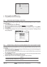
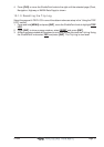
5. Move the ShuttlePoint knob to highlight DISTANCE or TIME step interval and press
[ENT] or move the ShuttlePoint knob to the right.
6. Move the ShuttlePoint knob up/down to the desired step value and press [ENT] or move
the ShuttlePoint knob to the right.
7. Press [CLR] or move the ShuttlePoint knob to the left until the Chart page is shown.
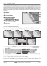
10.0 TRACKING
You may have to take a few trips to see how you like the Distance or Time Interval setup
on the previous step. When using the tracking feature you will notice every time a Track
Point is layed down on the Chart page a small filled in circle is shown on the Track line. If
you move the cursor over the active track line, a popup window will be shown with the Time,
Water Temperature (shown when FF520 is connected), Speed and Course Over Ground
(COG): this is very useful if you are fishing and want to review the conditions where the fish
were being caught.