


Page 62 CP500
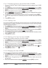
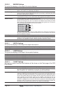
12.0 CHART PAGE
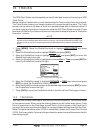
The Chart page is the main page of the GPS Chart Plotter. From this page the user can zoom
In/Out, pan around the chart, show information about cartographic objects, see the exact
vessel position with the COG and SOG, place points, GOTO a destination point, show Track
history etc. The GPS Chart Plotter is provided with a Worldwide background showing C-
MAP NT
+
/MAX detail up to 2.0 NM. For more detail, optional C-MAP NT
+
/MAX C-CARDs
are used.
Figure 12.0 - Charts and general text area
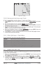
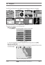
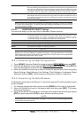
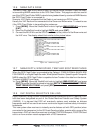
12.0.0 Window Selections
The window on the right side of the Chart page is called the General Window and it may be
edited, customized or even changed to show a highway or compass tape.
Figure 12.0.0 - Data window layout
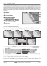
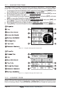
1. To change, press [MENU]. Move the ShuttlePoint knob to highlight SETUP MENU and
press [ENT].
2. Move the ShuttlePoint knob to highlight
GENERAL SETUP and press [ENT].
3. Move the ShuttlePoint knob to highlight
WINDOW SETUP and press [ENT].
4. Move the ShuttlePoint knob to highlight
CHART PAGE and press [ENT].
5. Select the desired window,
HIGHWAY or COMPASS, and press [ENT].
6. Press [CLR] or move the ShuttlePoint knob to exit the menu and show the Chart page.
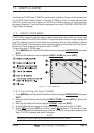
12.0.1 Additional Functions on Chart page
When on the Chart page, you will notice icons of Buoys, Towers, Lights, Wrecks, Tide