


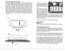
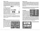
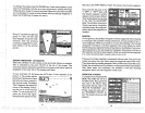
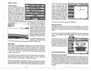

To
change
the
range, press
the RANGE
key.
A new menu
appears
at the
bottom of the
display.
Use
the
up
or down
arrow
keys
to
change
the
range
of the side scan
modefrom ten to
sixtyfeet.
Eitherwait
afew seconds
after
you've changed
the
range
and the
menus will
automatically disappear
or
press
the
CLEAR
key
to
erasethe
menus.
Group
"L" as shown
at
right
and
group
"U" also
use the side
scan
displays
along
with other
windows.
See the
windows
summaryon
page39foracom-
plete
listing
of all the
window
groups.
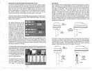
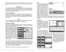
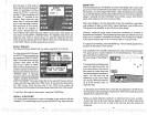
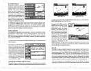
SONAR OPERATION
-
AUTOMATIC
When the UltraNav
II is first turned
on,
the Automatic
feature is enabled.
This is indicated
by
the word
"AUTO" at the
top
of the screen. The
Automatic feature
adjusts
the sensitivity
and
range
so
the bottom
signal
is
displayed
in
the lower half of
the screen at all
times.
To turn
Automatic
off,
first
press
the AUTO
key.
A
menu
appears
at the
bottom
of the screen
above
_________
theleftandrightarrows.Press
151.2
FTIF 0
the left arrow
key
to switch
to
the manual
mode. The
letters
"Man"
appear
in the
upper
left
corner
of the
display,
indicat-
ing
the
unit
is in the
manual
mode. To turn Automatic
on,
press
the AUTO
key
again,
then
press
the
right
arrow
key.
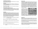
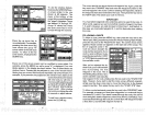
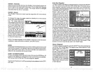
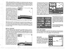
key
next to the "WPT
RECALL' label. The
screen shown
below
appears.
Now
press
the
key
next to the
"÷ WPT" or
"-WPT" label until
the
desired
waypoint
number
appears
on the screen. When it
does,
simply pressthe key
next
to
the "GO TO WYAPOINT"
label. The UltraNav II returns to
the last used
sonar,
navigation,
orplotterscreen, showing
navi-
gation
data to the
waypoint you
recalled.
ROUTES
A route
gives you
the
abilityto navigate
to
several
waypointswithout
having
to
re-program
the unit after
arriving
at
each one. A route
consists of two or
more
waypoints.
When
you
travell on a
route,
the
UltraNav It first shows
navigation
information to the
first
waypoint
in the route.
When
you
reach
the
firstwaypoint, (signalled bythe
Arrival
Alarm),
the
UltraNav II automati-
cally sequences
to the next
waypoint. Navigation
information is shown to
this
waypoint
and the
process
repeats.
When
you
reach the last
waypoint
in a
route,
the arrival alarm sounds until
you
turn it off.
There arefour
steps required
to create
and follow a route.
First,
you
must
create and name the route.
Next,
select the
waypoints
used in the
route.
Then determine the
starting waypoint. Next,
tell the unitto
follow the route.
Finally,
the unit will
askyou
if
you
wish to run the routeforward
orbackward.
After these
steps
are
completed,
the UltraNav II
will start
showing
navigation
data to the first
waypoint
on the route.
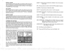
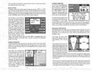
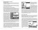
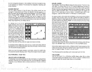
CREATING A ROUTE
To
create a
route,
first
press
the
MENU
key
white the unit is in
the OPS mode.
Next,
pressthe
key
next to the "More" label.
Now
press
the
key
next to the
"ROUTE PLANNING" label.
Finally, press
the
key
next to
the "SAVE/EDIT ROUTE" la-
bel. The screen
shown.at
right
appears.
.
TE
RQUTE4@
1
HAME:
::::::g:::E:EE:E:
gEEEEEEEE
aRTE
J.iJPT#
1
NAME
LAT
ILON
UERD BROS
N
36°09.869'
bi
95°37.171'
—'--I'
12
65
PDF compression, OCR, web-optimization with CVISION's PdfCompressor