


it
does,
your
local time and
possibly
date
display
will
probably
be
wrong,
Use the method shown above to setthe time and date to their
proper
local
settings.
Oncethis is
done,
an internal clockwill
keepthecorrecttime,
even
when the unit is turned off. The GPS
system updates
this clock
when the
unit is locked on to the satellites.
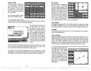
POSITION/NAVIGATION DISPLAYS
The
UltraNav II has a
position
screen,
navigation
screen,
plotter, steering
indicator,
and a satellite information screen. These
displays
were de-
signed
to show the most
important
data.
However,
you
can customize
all
of them
(except
the satellite
position screen)
to some extent
through
the
"Change Display"
feature on the first GPS menu screen.
(There
are other
screens that can be customized
by using
the Windows feature. See the
•
Windows section for more
detail.)
To customize these
screens,
see the
'Customize" section.
IMPORTANT!
If the data shown in
digital
numbers on
any
screen on this unit is
flashing,
then it means that data is invalid. Do not
rely
on that data if it is
flashing.
For
example,
if the
position display
is
flashing,
then the unit has lost the
satellites and hasn't
re-aquired
them. The
position
that is
flashing
is
your
last known
position, notyour present position!
Do not
navigate
with this unit
until
you
have found the reason the unit has lost the satellites!
Each of the
following
screens is available
by
first
pressing
the MENU
key,
then
pressing
the
key
next to the desired screen label. A detailed
description
of each screen follows.
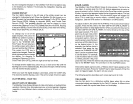
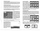
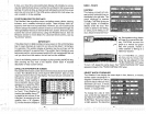
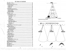
SATELLITE INFORMATION SCREEN
The satellite information screen shows technical data about each
satellite
in view. The UltraNav II has a five channel GPS receiver. Data on each
channel is shown
atthetop
of the
display.
The channels are numbered one
through
five on the left side of
the screen.
Every
satellite in
the
constellation has a number
______
assigned
to
it,
called the PRN.
____
The
PRN is the first number
in
the channel's row. TIRK stands
for
"track.' If the UltraNav II is
tracking
the
satellite,
then a 'T'
is
placed
in this column. If the
UltraNav II
issearchingforthe
satellite,
then a 'S'
appears.
ELV is the elevation
(height)
of
MENU
-
PAGE 4
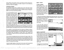
FASTRAK
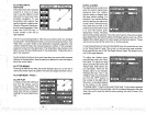
This feature
converts all
ech-
oes to short
horizontal lines on
the
display's
far
right
side. The
graph
continues to
operate
•
normally.
FASTRAK
gives you
a
rapid update
of conditions
directly
under
the boat. This
• makes
it useful for ice
fishing,
or when
you're
fishing
at
an-
chor. Since the boat isn't mov-
ing,
fish
signals
are
long,
drawn
out lines on a normal
chart dis-
play.
FASTRAK converts the
graph
to a
vertical bar
graph
that,
with
practice,
makes a
useful addition to
fishing
at a
stationary
location.
To turn FASTRAK
on, press
the menu
key
four
times,
then
press
the
key
adjacent
to the
"TURN FASTRAK ON" label.
To turn it
off,
repeat
the same
steps.
The 'TURN
FASTRAK OFF" label
appears
instead of the "TURN
FASTRAK ON" label.
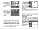
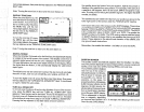
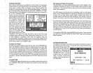
SELECT UNITS OF MEASURE
The U!traNav
II can
display
the
water
depth
in
feet, fathoms,
or
meters,
surface water
temperature
in
degrees
Fahrenheit or
Celsius,
speed
in statute miles
per
hour,
kilometers
per
hour,
or
knots,
and distance
(log)
in
miles,
kilo-
meters,
or nautical miles.
To
change
the units of mea-
sure,
press
the
key adjacent
to
the "SELECT UNITS OF MEA-
SURE" label.Thescreen shown
at
right appears.
The black box
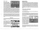
PA GE 4
N U RE
13 1 6O0i3110 3S
___
12
1
S 1270132401 29
____
"b2 N
1
N
i
dfl2
14
1
T
I 19°i 74°i
35
HOOP 1.69
I3DIJP 3.87
pOOp 3.33
TDOP 1.98
UDOP 2.87
13 02 06 24
12 14
SPEED.
=
IUI
KH KMH
50 27
PDF compression, OCR, web-optimization with CVISION's PdfCompressor