


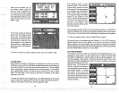
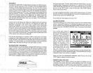

BAR" label.
Note:
Turning
the zoom
bar
on also
turns the zoom
feature on.
DISPLAY
ZONE
BAR
When the
zone alarm
is
on,
the
zone
bardoesn't
normallyshow
on the
screen. To
turn the zone
baron
continuously,
first
press
the
MENU
key
until the 3rd
menu
page appears.
Now
press
the
key
next to the
"DISPLAY
ZONE BAR"
label.
To turn the
zone bar
off, press
the MENU
key
until the
third
_____________________________
menu
page
appears,
then
press
the
key
adjacent
to the
"REMOVE
ZONE BAR" label.
Note:
Turning
the
zone bar on also
turns the zone
alarm on.
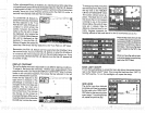
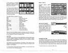
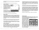
DIGITAL
SONAR
When the
UltraNav Ills
turned on
forthe first
time,
the
digital depth
display
is
located at the
top
left corner of
the screen.
This
display
comes
from a
separate digital
sonar built into
the unit. It
displays only
the bottom
depth.
If it loses the
bottom,
the
last known
depth
will
flash
on the
display.
When
the
digital
finds
the
bottom,
it will
automatically display
the
valid bottom
depth again.
The
digital
sonar can be
turned
off,
however this also
turns all automatic
features
off
also,
such
as auto
sensitivity,
auto
ranging,
and Fish I.D.
To turn
the
digital
sonar
off,
press
the
Menu
key
three times.
Now
press
the
key
adjacentto
the
'TURN DIGITAL SONAR OFF"
label, to turn it back
on
again, repeat
the
same
steps.
TURN
ALL SONAR OFF
To turn all
sonarfunctions off
and turn
the UltraNav II into a
OPS receiver
only, press
the MENU
key
until the
'TURN ALL SONAR
OFF" label
appears.
Press the
key
next to
that label. This turns the
digital
sonar and
the chart sonar off.
Repeat
the
above
steps
to turn
the sonar on. The
label
at the bottom of
sonar menu
page
3 now reads
"TURN ALL
SONAR ON."
Pressing
the
key
adjacent
to
that label starts
all sonar functions.
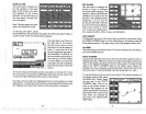
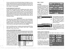
direction of the satellite from
your
position.
For
example,
if the azimuth of
a
satellite is 180
degrees,then
it is due south.
SNR is the
signal-to-noise
ratio. This tells
you
how
strong
the satellite's
signal
is. The
higherthe
SNR
number,
the
better.
The
satellites that are visible in the
sky
from
your position
are shown
in the
lower
right
corner of the screen under
the "VISIBLE SATS"
heading.
In
the lower left corner of the
screen are the DOPS
displays.
These show
you
the
"Dilution Of Precision"
(DOP)
forthe horizontal
(HOOP), geometric
(GDOP), position (PDOP),
time
(TDOP),
and vertical
(VDOP).
The GDOP
is
the combination value of
HDOP, VDOP,
and
TDOP. The smaller the
GDOP's number
is,
the
better. The OPS receiver
selects satellites based
on
GDOP,
therefore it
always
tries to use satellites
that have
good
DOP
values. These
depend
on the azimuth and
elevation of the
satellite,
and
any ground
based obstructions.
Remember,
the smaller the number
-
the
better on all of the
DOPs.
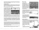
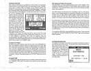
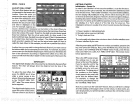
POSITION SCREEN
The
position
screen
automatically appears
after the UltraNav II is
initial-
ized. The
position
display
shows
yourpresent
position,
course
overground
(COG),
cross
track error
(XTE),
Your
present
position displays
near the
top
of
the screen in
latitude/longitude
coordinates.
This is shown
in
minutes,
and
thousandths
of a minute. For
example,
on this.
page,
the
—
—
present position
is 36
degrees,
__________
8.856 minutes
latitude and 95
degrees,
50.496 minutes Ion-
gitude.
Belowthe
present
posi
_____ ______
tion on the left side
is the Bear _____________
ing
to
Waypoint (BRG) display.
This is
expressed
in
degrees
true
or
magnetic, depending
on the
mode the UltraNav II is in. To
the
right
of the
Bearing
is the Course
Over Ground
(COG)
display.
menu
page appears,
then
press
the
key adjacent
to the
"REMOVE
ZOOM
the
satellite above the horizon
from
yoUr position.
AZM
is the azimuth
or
4.'
AUTO
5fl3FT
4.C
.oZ
U
H
I
bearing
(BRG),
and local time.
h — — ' —a-——
N
36°O8856'
U
95°50.496'
.850
MI
287G M
PIIH1L
tOl MI
26
51
PDF compression, OCR, web-optimization with CVISION's PdfCompressor