


MENU
-
PAGE 1
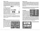
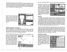
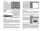
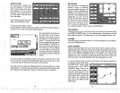
CHART SPEED
The rate
echoes scroll
across
the screen
is called the
chart
speed.
it's
adjustable
by
first
pressing
the menu
key,
then
pressing
the
key adjacent
to
the
"ADJUST CHART
SPEED"
label. The chart
speed menu
appears
at the
bottom of the
screen. Increase
the chart
speed
by pressing
the
right
ar-
row
key
or
decrease it
by
pressing
the left arrow
key.
The
percentage
of
chart
speed
in use
changes
as
the
arrow
keys
are
pressed.
The bar
chart also
gives
a
graphical
indication of the
chart
speed.
You
can seethe
change
on the
screen
(both
on the
menu
and
on the chart
record)
as
you
press
the
keys.
After
you've
madethe
adjustment,
press
the
CLEAR
keytb
erasethe menu.
To
stop
the
chart, press
the
key
adjacent
to
the "STOP" label.
To
start the
chart,
press
the
key adjacent
to the 'START"
label.
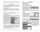
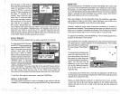
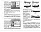
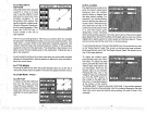
GRAYLINE°
GRAYLINE lets
you
distinguish
between
strong
and weak
echoes. It
"paints" gray
on
targets
that are
stronger
than a
preset
value.
This allows
you
to tell the
difference
between a hard and
soft bottom.
For
example,
a
soft,
muddy
or
weedy
bottom returns a
weaker
signal
which is
shown with
a narrow or
no
gray
line.
A hard
bottom returns a
strong
signal
which
causes a
wide
gray
line.
If
you
have
two
signals
of
equal size,
one with
gray
and
the other
without,
then
the
target
with
gray
is the
stronger signal.
This
helps distinguish
weeds
from trees on
the
bottom,
or
fish from
structure.
GRAYLINE is
adjustable.
Since
GRAYLINE
showsthe difference
between
strong
and weak
signals, adjusting
the
sensitivity
may require
a
different
GRAYLINE
level, also. The level
chosen
by
the
UltraNav II at
power
on is
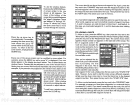
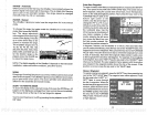
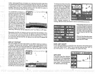
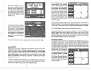
cursor. To
do
this,
first
press
one of
the arrow
keys.
This
makes the
plotter
cursor lines
appear
on the
display.
Now
move the lines to the
desired
pôsitionon
the
displaybypress-
ing
the arrow
keys.
When
it's at
the desired
location, press
the
EVENT MARKER
key,
then
select an
icon. The UltraNav II
places
the
icon at the intersec-
tion of the
ploçter
cursor lines.
UJ 95*5O.496
SO.?
.
22,0
W
E
s
To
erase the cursor
lines,
press
the
CLEAR
key.
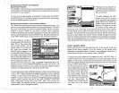
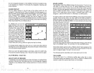
Erasing
the Icons
Although you
can
place
icons on the
plotter individually,
you
can't
erase
them one at a time. You have
to erase the
whole
group
of icons.
For
example,
if
you've place
20 fish
symbol icons,
erasing
one of them
erases
all 20.
To erase an
icon,
first
press
the EVENT
MARKER
key. Next, press
the
key
next
to the "DELETE ICON BANK"
label. The screen
shown below
appears.
Now
select the
group
of icons
thatyou
wish to erase
by press-
ing
the
key
next to the desired
icon.
Afterpressing
the
key,
the
UltraNav Ii erases all of
the
selected icons
from the
plotter.
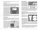
WAYPOINT NAVIGATION
HOW TO SAVE A WAYPOINT
'I?
,
SELECT
AN ICON
GROUP TO ERASE
''
156°
FROM
PLOTTER.
I4ARNING!
'is,
Waypoints
are
locations on the earth's surface that
you
wish to
go
or return
to.
Waypoints
are
useful for
marking shipwrecks,
hot
fishing spots,
and
otherfishing
or
navigation
locations.
Storing waypoinfs
in the UltraNav Ti's
memory
makes
iteasyto
return to
any point
in the
world
bysimply
pressing
afew buttons.
The UltraNav II can store
upto
200
waypoints.
You can
store
your present position
as a
waypoint
or enter
latitude/longitude positions
as
waypoints.
Ma0O9.Oo2
W
95°50.389'
16
61
PDF compression, OCR, web-optimization with CVISION's PdfCompressor