


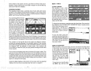
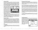

At
the bottom of the screen are the Local Time and Cross Track
Error
Displays.
Please note that
you
must recall a
waypoint
to
use the
Bearing
and Cross Track Error
displays.
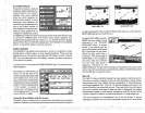
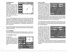
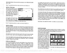
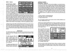
STEERING SCREEN
The
steering
screen
shows
a
pictorial
view of
your
boat and
course
travelled.
This is called a Course
Deviation
Indicator or CDI. It also
shows
Distance To Go
(DTG),
Speed
Over Ground
(SOG), Bearing
to
Waypoint
(BRG),
and Course Over Ground
(COG).
Your
present position
is shown
by
the arrow. The arrow shows
the direction the boat is head-
ing
relative to the
waypoint.
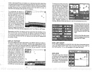
In
theory,
if
you
steer the
boat
with the arrow
always pointing
towards
thewaypoint,
then
you
•
will arrive at the
waypoint.
The
•
solid line
extending
from the
arrow is
your
track or
path
you've
taken. To travel
directly
to a
waypoint, try
to
keep
the
________________________________
•
arrow on the center line. The
depicted bya boxatthetop
of
the
CDI
display.
As
you approach
the
waypoint,
the arrow and the box will move
closertogether.
If
you
travel
pastthewaypoint,thewaypoint's
boxwill movetothebottom
ofthedisplay.
The numbers on
the
top
left side of the screen
are distance
markers,
showing
the
remaining
distance to the recalled
waypoint.
If the numbers
have
a black box
surrounding
them,
then the
distance markers is
showing
the distance PAST the
waypoint.
In other
words,
if the numbers are
surrounded
by
a black
box
then
you
have
passed
the
waypoint
and need
to turn around.
The numbers
immediately
below the CDI are the CDI
range
in miles. This
gives you
an idea of how far off course
you
are. For
example,
if the arrow
is
halfway
between the course line and the outside left line and the CDI
range
is 0.5
miles,
then
your
cross track error is to the left 0.25 miles. The
CDI
range
is the same as the CDI alarm
setting.
See the section on GPS
alarms to
change
the CDI
range.
Using
the
digital displays
at the bottom of the screen with the
graphical
display
at the
top
let
you accurately
steer the boat to a
waypoint.
MENU
-
PAGE 3
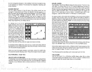
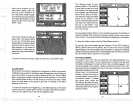
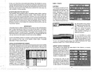
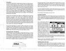
CHART CURSOR
The
UltraNav II
has a chart
cursor that allows
you
to
pin-
point
a
target's depth.
The cur-
sor
is
simply
a horizontal line
that extends
across the
display
from left to
right.
A
depth
box at
the end
of fhe line on the
right
side shows the
line's
depth.
In
the
example
below,
the cursor
(line)
is at
30.0 feet.
To
displaythe
chartcursor, pressthe
menu
keythree
times. Now
pressthe
key adjacent
to the
'TURN CHART CURSOR ON" label. A screen similar
to the one at the bottom
of this
page appears.
Use
the
up
or
down arrow
keys
to move the
cursor
up
or down to the de-
sired
depth.
To turn the chart
cursor
off,
pressthe
menu
keythreetimes.
Now
press
the
key adjacent
to
the 'TURN CHART CURSOR
OFF" label. The unit
returns to
the sonar screen.
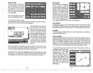
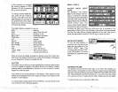
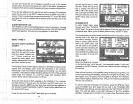
DISPLAY ZOOM BAR
When the unit is in the zoom
mode,
the zoom
bar
doesn't
normally
show
on the screen. The zoom bar shows the
section of water on the
right
side
of the
screen that the zoom
feature
displays
ontheleftside.
To turn
the zoom bar on con-
tinuously,
first
press
the MENU
key
until the
3rd menu
page
appears.
Now
press
the
key
next to the
'DISPLAY ZOOM
BAR" label.
To turn
the zoom bar
off,
press
the MENU
key
until the third
AUTO H 34.3
473
FT
52
25
PDF compression, OCR, web-optimization with CVISION's PdfCompressor