


CHANGE POSITION
Use a chart to determine
your position
if
you
don't know it. The
latitude!
longitude
that
you
enter doesn't have to be
extremely
accurate.
Typically,
if
you
enter a
position
within
one
degree
of
your
present
position,
the
UltraNav II should
quickly
find
your
actual
Iatitude!Iongitude.
To
change
your
present position,
first
press
the
key
next to the "CHANGE LAT" label.
The screen shown below
appears.
Use the down arrow
key
to
change
the
"N" to
"5",
if
necessary.
Next,
simply
enter
your present
lati-
tude
using
the numbered
keys.
Notice thatthe
position
entered
is in
degrees, minutes,
and
hundredths of a minute.
(Not
seconds!)
If
you
make a mis-
take,
press
the left or
right
ar-
row
keys
to move to the num-
ber in the latitude that needs
changing.Afterthe
latitude has
been
entered,
press
the
key
next to the "ACCEPT' label.
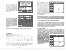
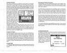
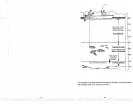
LATITUDE
N
36°08.862'
LONGITUDE hi
95°SO.484'
ALTITUDE 1696
LOCAL TitlE 10:17:23 PM
LOCAL DATE 1'03'1993
USE NUMERIC KEYS
UFD:''
&flW
Now
press
the
key
next
to the
"CHANGE LON" label. The black box will be next to the "E" on
the
longitude. Again,
use
the
up
or down arrow
keys
to switch the "E" to "W"
or west
longitude,
if
necessary.
Now enter the
longitude using
the
numbered
keys.
Be certain to enter a zero "0" as the first number in the
longitude
if it's lessthan 100
degrees! Afteryou've
enteredthe last
number,
press
the
key
next to the "ACCEPT" label.
CHANGE ALTITUDE
• To
enter
your present altitude, press
the
key
next to the "CHANGE ALT"
•
label. The UltraNav II needs to know
your
elevation above sea level.
(Not
your height
above the
ground.) Again,
an
approximation
is
usually
suffi-
cient. Use the numbered
keys
to enter
your
altitude data. Press the
up
•
arrow
key
if
your
altitude is below
sea level.
For
example, suppose you're
in Death
Valley
and the
spot you're standing
in is 35 feet below sea level.
You would need to enter the numbers
"35",
then
press
the
up
arrow
key
to
change
itto -35 feet. Press the
key
nexttothe "ACCEPT" label when
you're
done.
CHANGE TIME
To
change
the local time
(the
time at
your position), press
the
key
next to
the "CHANGE TIME" label. The screen shown at the
top
of the next
page
appears.
ASP
(Advanced Signal Processing)
The
ASP feature is a noise
rejection system
built into
the UltraNav II that
constantly
evaluates the effects of boat
speed,
water
conditions,
and
interference. This automatic feature
gives
you
the best
display possible
under most
conditions.
The ASP feature is an effective tool in
combating
noise. In sonar
terms,
cnoise is
any
undesired
signal.
It is caused
by
electrical and mechanical
sources such as
bilge pumps, engine ignition systems
and
wiring,
air
bubbles
passing
over the face of the
transducer,
even
vibration from the
engine.
In all
cases,
noise
cap produce
unwanted
marks on the
display.
The ASP feature
has two levels
-
Normal and
High.
If
you
have
high
noise
levels,
try using
the
"High"
ASP
setting.
However,
if
you
are
having
trouble
with
noise,
we
suggest
that
you
take
steps
to find the interference source
and fix
it,
rather than
continually using
the unit with the
high
ASP
setting.
However,
there are times when
you may
want to turn the ASP feature off.
This allows
you
to view all
incoming
echoes before
they
are
processed by
the ASP feature.
To
change
the ASP
level,
press
the MENU
key
five times.
Then
press
the
key
next to the "ADJUST LEVEL OF CHART ASP" label until
the desired
level is obtained.
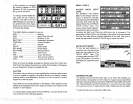
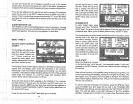
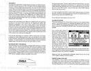
SYSTEM INFORMATION
The
System
Information menu
gives yoU
the date and revision number of
the software used in the Accura. To view this
menu,
press
the Menu
key,
then
press
the
key
next to the
____________
"More" label until the fifth menu
page appears.
Now
press
the
key
next to the "SYSTEM IN-
FORMATION" label. A screen
similar to the one at
right ap-
pears.
To return to the sonar
screen, press
the
key
next to
the
"Exit" label.
48
29
EAGLE
ELECTRONICS
COPYRIGHT 1992
CODE UERSIUN
——
U2.5B
PDF compression, OCR, web-optimization with CVISION's PdfCompressor