


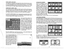
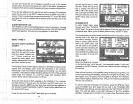
on each line shows the
unit of
measure
currently
in
use. In the screen
shown
below,
the
units of measure
are in feet for the
depth,
temperature
in
degrees Fahrenheit,
and both
speed
and
log
are in statute
miles
perhour.
Press the
key adjacent
to the unit
that
you
wish to
change.
For
example,
press
the
key
next to the
DEPTH label two times to
switch from feet to
meters. This
moves the black
boxtwo times from the "Fr"
to the "M".
When
you
have the units of
measure set as
desired,
press
the
key
next to
the
"EXIT"
label.
CLEAR
DISTANCE LOG
The UltraNav II
starts
counting
distance as soon as it is
turned on. To reset
the distance
log
to
zero,
pressthe
MENU
key
untilthe
"CLEAR DISTANCE
LOG" label
appears,
then
press
the
key adjacent
to that label.
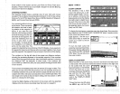
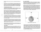
ADJUST CHART
SURFACE
CLARITY
The
markings extending
down-
ward from the zero line
on the:
chartare called
"surface clut-
ter." These
markings
are
caused
by
wave
action,
boat
wakes,
temperature inversion,
and other
natural causes.
ADJUST
E
TLEVELOF
CHART ASP
fl
HIGH
MINFORMATIQN
AGEIE
The Surface
Clarity
Control
(SCC)
reduces or eliminates surface
clutter
signals
from the
display.
5CC
varies the
sensitivity
of the
receiver,
decreasing
it near
the surface and
gradually increasing
it
as the
depth
increases. The maximum
depth
that
3CC will affect is 75% of the
selected
depth range.
For
example,
on a 0-60 foot
range
with
maximum
SCC,
surface
clutter will be reduced
down to 45 feet.
There are thre levels
of 8CC available on the
UltraNav II:
low, medium,
and
high.
When it's turned
on for the first
time,
the SCC
level is low. To
change
it,
press
the
MENU
key
five
times,
then
press
the
key adjacent
to
the "ADJUST CHART
SURFACE
CLARITY" label until the black box is on
the desired 5CC
level.
Press the
key
next to
the "EXIT"
label when
you're
finished.
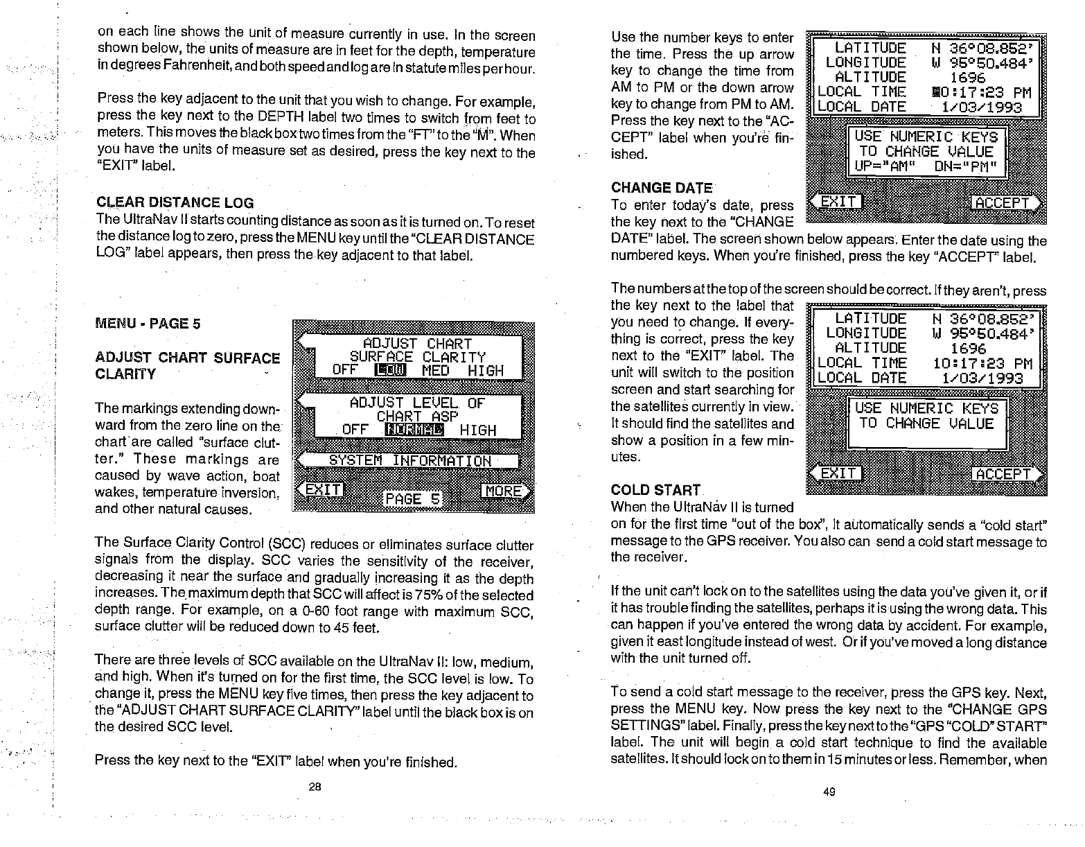
Use
the number
keys
to enter
the time. Press the
up
arrow
key
to
change
the time from
AM to PM or
the down arrow
key
to
change
from PM to AM.
Press the
key
next to the "AC-
CEPT"
label when
you're
f in-
ished.
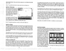
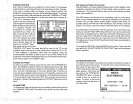
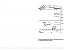
LATITUDE N
36°O8.82'
LONGITUDE hi 950E0.484'
ALTITUDE
1696
LOCAL TIME
O:17:23 PM
DATE 1/03/1993
.L9CAL
SUMERIKEYS
1
TO
CHANGE VALUE
UP="AM"DN=P
CHANGE DATE
____
To enter
today's date, press
aAccEPY
the
key
next to the "CHANGE
DATE"
label. The screen shown below
appears.
Enter
the date
using
the
numbered
keys.
When
you're
finished,
press
the
key
"ACCEPT" label.
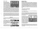
The
numbers atthe
top
of the screen should be correct. If
they
aren't,
press
the
key
next to the label that
you
need to
change.
If
every-
thing
is
correct,
press
the
key
next to the "EXIT" label. The
unit will switch to the
position
screen and start
searching
for
the satellites
currently
in view.
It should find the satellites and
show a
position
in a few min-
utes.
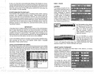
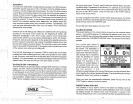
COLD START
When the UltraNáv II is turned
LATITUDE
N 36°O8.862'
LONGITUDE hi
%°EU.484'
ALTITUDE 1696
LOCAL
TIME 10:17:23 PM
DATE
1'03'1993
WUNERIc
KEYS
I
5
TO CHANGE VALUE
on for the first time "out of the
box",
it
automatically
sends a "cold start"
message
to the GPS receiver. You
also can send a cold start
message
to
the receiver.
If the unit can't lock
on to the satellites
using
the data
you've given it,
or if
it has
troublefinding
the
satellites,
perhaps
it is
using
the
wrong
data.
This
can
happen
if
you've
entered the
wrong
data
by
accident. For
example,
given
it east
longitude
instead of west. Or if
you've
moved a
long
distance
with the unit turned off.
To send a cold start
message
to the
receiver, press
the GPS
key.
Next,
press
the MENU
key.
Now
press
the
key
next to thefl "CHANGE GPS
SE1TINGS" label.
Finally, press
the
key
nextto the "GPS "COLD" START'
label. The unit will
begin
a cold start
technique
to find the available
satellites. It should lockonto them in
15 minutes or less.
Remember,
when
MENU
-
PAGE 5
28
49
PDF compression, OCR, web-optimization with CVISION's PdfCompressor