


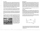
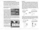
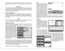

Surface
Mounting
-
Without Access
If
you
don't have
access to the
back side of the
mounting surface,
use
the "cleats"
supplied
with the
UltraNav II.
(Note:
This is
assuming you
can "snake" the
module's
cableto a
location that is
accessable. A hole
will still need
to be drilled in
the
mounting
surface for the
cable.) Using
the
gasket
as a
template,
mark and drill
the 17mm
(11/16")
hole for the
cable.
Attach the cable to
the
module .and
dropthe
other end of the
cable
through
the
gasket
and down the
hole. Place the
module on the
gasket.
Slide
the
"cleats" onto each
end of the module
and
(using
the
cleats
as
templates)
mark four holes for
5 mm
(#10)
mounting
screws.
Drill the
holes,
then
replace
the cleats
on the module and
fasten them
to
the
mounting
surface
with 5 mm
(#10)
screws.
Route the cable to the
UltraNav II.
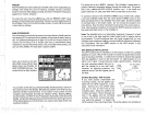
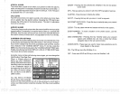
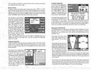
strength (the higher
the num-
ber,
the
better),
and the
signal-
to-noise ratio
(SNR).
The
high-
erthe SNR
number,
the
better,
also.
The lower half of the
screen
shows statistics for
each of the
receiver's five channels.
This
includes the
satellite number
(PRN),
its
status
(STAT),
the
User
Differential
Range
Error
(UDRE),
Time status
(TIME),
and if SA
(Selective
Availablity)
is on or off.
The
UDRE is the
range
error
from
your position
to the
satellite. If there is
an "OK"
in this
field,
then the
range
errorto that
satellite is 8 meters or less
68
percent
of the time.
For mOre
information,
read
your
beacon
receiver's manual.
SELECT UNITS
OF
MEASURE
(See
the
Select Units of Measure in the
Plotter section of
this
manual.)
TRUE and
MAGNETIC POSITION
True and
magnetic
north are not
always
the
same. True north is
the
top
of
the world.
It's where all lines of
longitude
converge. Magnetic
north is the
location our
compasses point.
It lies
several hundred
miles to the south of
true
north,
at a location in
Canada.
Charts are
usually
laid out
according
to
aMercatorprojectionthatuses true
north. If
you ptot
a
course on chart
using
the
Mercator
projection, you'll
either have to convert
magnetic readings
to
true or use true
readings.
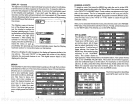
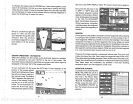
The UltraNav II
can
display navigation
information in
magnetic
or
true.
When it's turned on for
the first time
magnetic
is used. To switch to
true,
press
the MENU
keywhile
a GPS screen is
displayed.
Next,
press
the
key
next to the
"CHANGE GPS SETTINGS" label.
Now
press
the
key
next to
the "SELECT UNITS
OF MEASURE' label.
Nowsimply pressthe key
next
to the "BEARING"
label; This moves the black
box from "MAG" to "TRU."
Press the
key
next to the "EXIT" label
when
you're
finished.
4
73
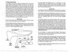
"CLEAT"
•
DRILL
FOUR
PLACES
GA5
CABLE
PDF compression, OCR, web-optimization with CVISION's PdfCompressor