


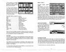
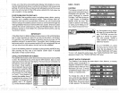
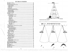
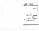

Very
small fish
probably
will not arch
at all. Medium sized fish will show a
partial
arch,
or a
shape
similarto an arch if
they're
in
deep
water.
Large
fish
will
arch,
but turn the
sensitivity up
in
deeper
water to see the arch.
.
.
Because of
waterconditions,
such as
heavy
surface
clutter,
thermoclines,
etc.,
the
sensitivity
sometimes
cannot be increased
enough
to
get
fish
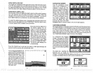
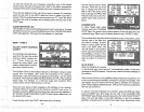
One of the best
ways
to
get
fish arches is to
expand
or "zoom" a
segment
of the water. For
example,
from 45 to 60 feet. The smallerthe
segment,
the
better the screen
resolution will be. The
easiest
way
to do this on the
UltraNav II is
with the Zoom feature. This feature
expands
the
echoes,
making
it easier to see detail. For the best
results,
turn the
sensitivity up
as
high
as
possible
without
getting
too much noise on the screen. In
medium to
deep
water,
this
method should
work
to
display
fish arches.
If
you
see fish
signals
when the unit is in
the manual
mode,
but don't
get
fish
symbols
when the Fish I.D. feature is
on,
try increasing
the
sensitivity.
WATER TEMPERATURE AND
THERMOCLINES
Water
temperature
has an
important-if
not
controlling-influence upon
the
activities of
all
fish.
Fish are cold blooded and their bodies are
always
the
temperature
of the
surrounding
water.
During
the
winter,
colder water
slows down their metabolism. At this
time, they
need about a fourth as
much
food as
they
consume in
the summer.
Most fish don't
spawn
unless the
watertemperature
is within rather narrow
limits. A
surface
temperature
meter
helps identify
the desired
surface
water
spawning temperatures
for various
species.
Trout can't
survive
in
streams
that
get
too warm. Bass and other fish
eventually
die out when
stocked in lakes
that remain too cold
during
the summer. While some fish
• have a wider
temperature
tolerance than
others,
each has a certain
range
•
within which it tries to
stay. Schooling
fish
suspended
over
deep
water lie
at the
level that
provides
this
temperature.
We assume
they
are the most
comfortable here.
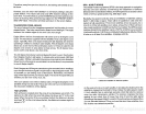
The
temperature
of water in the lake is seldom constant from
top
to
bottom.
Layers
of different
temperatures form,
and the
junction
of
a warm and cool
layer
of water is called a
thermocline. The
depth
and thickness of the
thermocline can
vary
with the
season
or
time of
day.
In
deep
lakes there
may
be two or more at
different
depths.
Thermoclines are
important
to
fishermen because
they
are areas where fish are active.
Many
times bait
fish will be above the
thermocline while
larger game
fish will
suspend
in or
just
below it.
ULTRANAV H
GPS
OPERA11ON
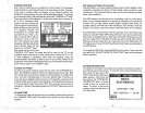
WARNING!
USE THIS GPS RECEIVER
ONLY AS AN AID TO NAVIGATION. A
CAREFUL NAVIGATOR
NEVER RELIES ON ONLY ONE METHOD TO
OBTAIN POSITION INFORMATION.
CAUTION
This GPS
receiver, (like
all GPS
navigation equipment)
will show the
shortest,
most
direct
path
to a
waypoint.
It
provides navigation
data to the
waypoint regardless
of
obstructions.
Therefore,
the
prudent navigator
will
not
only
take
advantage
of all available
navigation
tools when
travelling
to
a
waypoint,
but
will,also
visually
check to
make certain a
clear,
safe
path
to
the
waypoint
is
always
available.
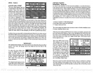
NOTICE!
As of this
writing,
the
Department
of Defense
(DOD)
has not declared the
GPS
navigation system operational.
The
system
is
still
in a
testing phase.
Satellitescan beturned off
oraccuracycan
be
degraded
atwill
bythe system
operators.
Remember that the UltraNav
II,
or
any
GPS
receiver is
only
as
accurate as the
system
it's
using.
34
43
PDF compression, OCR, web-optimization with CVISION's PdfCompressor