


3-1
3. BERTHING DISPLAY
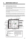
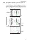
3.1 Berthing Display Overview
The berthing display shows ship’s track (past and/or predicted) and provides help with
berthing operations. With position and heading inputs, customizable berthing lines can
be shown to help in berthing.
The display orientation is available in Head-up and North-up. Head-up has your head-
ing at the screen top and North-up has North at the top.
The navigation data, which appears at the left side of the display, can be shown or hid-
den as necessary.
Current (tide) direction and wind angle markers, shown with blue and purple triangle
markers respectively, provide quick identification of respective direction or angle.
The 3-axis speed display shows ship’s speed in three axes: transverse speed at the
reference point, longitudinal speed, and transverse speed at the stern. The display is
positioned at the bottom-right corner or top-left corner depending on the location of the
own ship marker. You can show or hide the display as required.
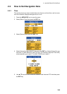
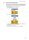
KOBE-1
1.5
231
3.2
321
123
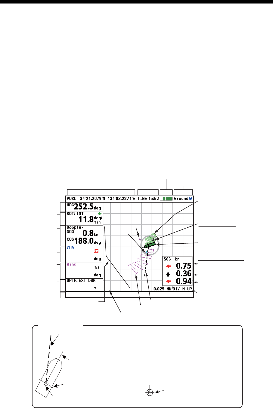
The own ship marker indicates current position.
The marker is green for ground tracking and blue
for water tracking. The marker is scaled
according to ship length and width, set on the
[Setting Ship Data] menu. If the range and
dimensions of the ship are as shown below, the
marker is shown with concentric circles.
Range x 8 > Ships length x 30, or Width x 52
Heading Line
(Indicates your heading.)
Beam Line
Speed Vector (Shows predicted
ship position at end of selected
time interval.)
Own ship
marker
Own ship marker
CCRP
(Consistent Common Reference Point)
3-axis speed display
Tracking mode monitor*
Time
Position
Past position marker
Ground tracking: light green
Water tracking: light blue
Current (tide) speed,
direction
Wind reference
wind speed
wind angle
Doppler sonar
SOG(STW), COG
Depth
(below keel)
Range/Display
orientation (N UP, H UP)
Transverse speed at
reference point
Longitudinal speed
Transverse speed at stern
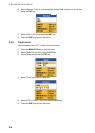
Name of berthing line
ROT source,
ROT
Berthing
line
Speed vector
Own ship marker*
(current position)
Predicted position marker (purple)
Wind angle
marker (purple)
Current
(tide)
direction
marker
(blue)
Heading
Message area
Tracking mode
Track (solid line)
Stern track: black
Ref. pos. track: green*
* Green: ground tracking
Blue: water tracking
SPEED ALARM 300