


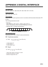

APPENDIX 2 DIGITAL INTERFACE
AP-4
GGA - Global Positioning System Fix Data
GLL - Geographic position
GNS - GNSS Fix Data
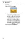
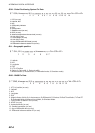
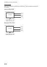
$ ** GGA, hhmmss.ss, lill.ll, a, yyyyy.yy, a, x, xx, x.x, x.x, M, x.x, M, x.x, xxxx *hh <CR><LF
>
1 2 3 4 5 6 7 8 9 10 11 12 13 14
1. UTC (no use)
2. Latitude, N/S
3. N/S
4. GPS quality indicator
5. E/W
6. Quality index
7. Satellites used (no use)
8. DOP (no use)
9. Antenna height above the sea level (no use)
10. Unit (M) (no use)
11. Geoid height (no use)
12. Unit (M) (no use)
13. Age of differential GPS date (no use)
14. Differential reference station ID (no use)
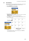
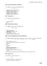
$ ** GLL, llll.ll, a, yyyyy.yyy, a, hhmmss.ss, x, x *hh <CR><LF>
1. Latitude
2. N/S
3. Longitude
4. E/W
5. UTC of Position
6. Status (A: Data valid, V: Data not valid)
7. Mode indicator (A: Autonomous, D: Differential mode, S: Simulator mode)
1 2 3 4 5 6 7
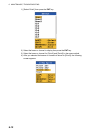
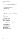
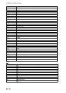
$ ** GNS, hhmmss.ss, llll.ll, a, yyyyy.yyy, a, cc, xx, x.x, x.x, x.x x.x, x.x *hh <CR><LF>
1 2 3 4 5 6 7 8 9 10 11 12
1. UTC of position (no use)
2. Latitude
3. N/S
4. Longitude
5. E/W
6. Mode indicator (N=No fix, A=Autonomous, D=Differential, P=Precise, R=Real Time Kinetic, F=Float R
T
E=Estimated Mode, M=Manual Input Mode, S=Simulator Mode
7. Total number of satllite in use (no use)
8. HDOP (no use)
9. Antenna altitude (no use)
10. Geoidal separation (no use)
11. Age of differential data (no use)
12. Differential reference station ID (no use)