


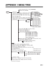
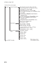

APPENDIX 2 DIGITAL INTERFACE
AP-5
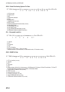
HDG - Heading, Deviation and Variation
HDT - Heading True
MWV - Wind Speed and Angle
RMC - Recommended Minimum Specific GNSS Data
ROT - Rate of Turn
$ ** HDG, x.x, x.x, a, x.x, a *hh <CR><LF>
1 2 3 4 5
1. Magnetic sensor heading, degrees
2. Magnetic deviation, degrees
3. Magnetic variation, degrees E/W
4. Magnetic deviation, degrees
5. Magnetic variation, degrees E/W
$ ** HDT, xxx.x, T *hh <CR><LF>
1 2
1. Heading, degrees
2. True
$ ** MWV, x.x, a, x.x, a, A *hh <CR><LF>
1 2 3 4 5
1. Wind angle (degrees)
2. Reference, R=relative, T=true
3. Wind speed
4. Wind speed units, K/M/N
5. Status, A=data valid, V=data invalid
$ ** RMC, hhmmss.ss A, llll.ll, a, yyyyy.yy, a, x.x, x.x, xxxxxx, x.x, a, a, *hh <CR><LF>
1 2 3 4 5 6 7 8 9 10 1112
1. UTC of position fix (no use)
2. Status: A=data valid, V=navigation receiver warning
3. Latitude
4. N/S
5. Longitude
6. E/W
7. Speed over ground, knots
8. Course over ground, degrees true
9. Date: dd/mm/yy (no use)
10. Magnetic variation, degrees E/W (no use)
11. E/W
12. Mode indicator (A=Autonomous mode, D=Differential mode, S=Simulator mode)
$ ** ROT, x.x, A *hh <CR><LF>
1 2
1. Rate of turn, deg/min, "-"=bow turns to port
2. Status: A=data valid, V=data invalid