


107
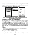
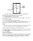
To stop navigating to the cursor, use the Cancel Navigation command:
press
MENU|MENU|↓ to CANCEL NAVIGATION|ENT|← to YES|ENT. The
Cuda stops showing navigation information.
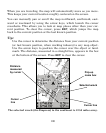
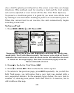
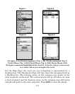
Navigate to a Map Place
For map places that are in view on the map, you can easily use the
Navigate to Cursor command above; just use the cursor to select the
map place.
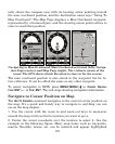
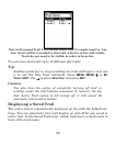
The other method involves searching for map places with the Fin
d
Waypoint command, launched with the WPT key. Turn to Sec. 9,
Searching, for detailed instructions on map place searches.
A
fter you have looked up an item with the Find Waypoint command,
use the → to make sure the
GO TO command is highlighted at the bot-
tom of the screen, then press
ENT. The Cuda begins showing navigation
information to the item.
To cancel navigation, press
MENU|MENU|↓ to CANCEL NAVIGATION|ENT|
←
to YES|ENT. The Cuda stops showing navigation information.
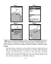
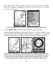
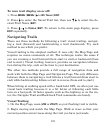
Creating and Saving a Trail
A
trail, or plot trail, is a string of position points plotted by the Cuda
350 as you travel. It's a travel history, a record of the path you have
taken. Trails are useful for repeating a journey along the same track.
They are particularly handy when you are trying to retrace your trip
and go back the way you came. On the screen, trails are represented b
y
a flashing line extending from the back of the current position arrow.
The Cuda is set at the factory to automatically create and record a trai
l
while the unit is turned on. The unit will continue recording the trail un-
til the length reaches the maximum trail point setting (default is 2,000,
but the unit can record trails 9,999 points long). When the point limit is
reached, the Cuda begins recording the trail over itself.
By default, the trail flashes once a second, making it easier to see
against the background map. With the default setting, the Cuda cre-