


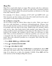
134
Map Fix
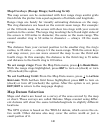
Map Fix is used with charts or maps. This system asks for a reference
position in latitude/longitude, which you take from a marked location
on the map. It then shows the present position as distance on the map
from that reference point.
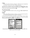
For example, if it shows a distance of UP 4.00" and LEFT 0.50", you
then measure up four inches and to the left a half-inch from the refer-
ence point on the map to find your location.
To configure a map fix:
To use setup a map fix, follow these steps in order. Take your map o
f
the area and determine a
reference latitude/longitude. (Please note
that in order for this system to work, the latitude/longitude lines must
be parallel with the edge of the map. USGS maps are parallel, others
may not be. Also, this works better with smaller scale maps.) The ref-
erence position can be anywhere on the map, but the closer it is to you
r
location, the smaller the numbers will be that you will have to deal
with. Once you have decided on a reference position, you can save it as
a waypoint. See the waypoint section for information on saving a way-
point. Save the reference position as a waypoint. Exit from the way-
point screens.
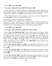
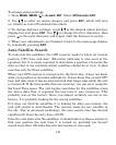
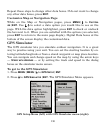
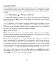
1. Press
MENU|MENU|↓ to GPS SETUP|ENT.
2. Press ↓ to
COORDINATE SYSTEM|ENT.
3. Press ↓ to
SETUP MAP FIX|ENT.
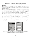
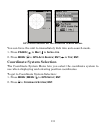
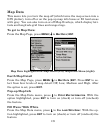
The following screen appears and
MAP SCALE is highlighted. Press ENT
and enter the map's scale. This is generally at the bottom of the pape
r
map. It is shown as a ratio, for example 1:24000. Press EXIT
and the
unit returns to the Configure Map Fix screen.