


70
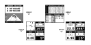
PCF OFFSET
The GPS navigation system relies on complex math-
ematical calculations to determine your position based
on satellite data and other factors. One factor is the
Earth's shape. Since the Earth is not a true sphere,
variations in the calculations have to be made to accom-
modate deviations. To make matters more complex, not
everyone uses the same data to determine what the
deviations are. The size and shape of the ellipsoids that
are used to approximate the earth's surface are im-
proved often. This can lead to errors if your navigation
device uses one ellipsoid, while your chart uses a
different one. The term used for these ellipsoids is
"Datum."
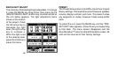
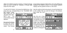
To reduce the error factor between datum, this unit gives
you the capability to move or "offset" the position shown
on the display to match the one on the chart. The unit will
add this offset to all position displays at all times.
Remember, the GPS error is very dynamic and the PCF
offset should never be used in an attempt to cancel the
error. In general terms this feature should only be used
if your map indicates what the possible error is. This
feature should always be reset to zero (0) when
you're finished with that chart.
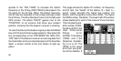
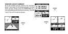
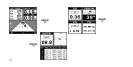
For example, suppose you are stopped at a location that
is accurately marked on a chart. Your unit shows a
longitude position that is .010 degrees less than the one
on the chart. Using the Position Correction Factor (PCF)
Offset feature, you make the unit read the same as the
chart. If you move, the unit will continuously add the
change to all position displays. This makes it more
closely match the datum used by the chart. For this
reason, you should be careful when entering the PCF