


APPENDIX
AP-13
GNS - GNSS fix data
HDT - Heading - true
LRF - Long-range function
LRI - Long-range interrogation
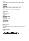
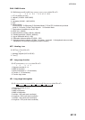
$**GNS,hhmmss.ss,llll.ll,a,IIIII.II,a,c--c,xx,x.x,x.x,x.x,x.x,x.x,a*hh<CR><LF>
1 2 3 4 5 6 7 8 9 10 11 12 13
1. UTC of position (no use)
2. Latitude (0.00000 - 9000.00000)
3. N/S
4. Longitude (0.00000 - 18000.00000)
5. E/W
6. Mode indicator
A=Autonomous D=Differential E=Estimated Mode F=Float RTK M=Manual Input Mode
N=No fix P=Precise R=Real Time Kinematic S=Simulator Mode
7. Total number of satellites in use (00 - 99)
8. HDOP (0.0 - 999.99)
9. Antenna altitude, meters (-999.99 - 9999.99)
10. Geoidal separation (-999.99 - 9999.99)
11. Age of differential data (0 - 999)
12. Differential reference station ID (0000 - 1023)
13. Navigational status indicator (S=Safe C=Caution U=Unsafe V=Navigational status not valid,
equipment is not providing navigational status indication)
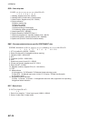
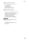
$**HDT, xxx.x,T*hh<CR><LF>
1 2
1. Heading, degrees (0.00 to 360.00)
2. True (T)
$**LRF,x,xxxxxxxxx,c--c,c--c,c--c*hh<CR><LF>
1 2 3 4 5
1. Sequence number (0 - 9)
2. MMSI of requester
3. Name of requester (1 - 20 characters)
4. Function (1 - 26 characters)
5. Function reply status
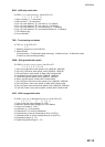
$**LRI,x,a,xxxxxxxxx,xxxxxxxxx,llll.ll,a,yyyyy.yy,a,llll.ll,a,yyyyy.yy,a*hh<CR><LF>
1 2 3 4 5 6 7 8
1. Sequence number (0 to 9)
2. Control flag
3. MMSI of requestor
4. MMSI of destination
5. Latitude - N/S (north-east coordinate)
6. Longitude - E/W (north-east coordinate)
7. Latitude - N/S (south-west coordinate)
8. Longitude - E/W (south-west coordinate)