


APPENDIX
AP-14
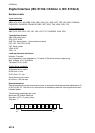
OSD - Own ship data
RMC - Recommended minimum specific GPS/TRANSIT data
ROT - Rate of turn
$**OSD, x.x, A, x.x, a, x.x, a, x.x, x.x, a *hh<CR><LF>
1 2 3 4 5 6 7 8 9
1. Heading, degrees true (0.00 - 360.00)
2. Heading status (A=data valid, V=data invalid)
3. Vessel course, degrees true (0.00 - 359.99)
4. Course reference
B=Bottom tracking log
M=Manually entered
W=Water referenced
R=Radar tracking (of fixed target)
P=Positioning system ground reference
5. Vessel speed (0.00 - 999.999)
6. Speed refereence, B/M/W/R/P (See 4.)
7. Vessel set, degrees true, manually entered (0.00 - 360.00)
8. Vessel drift (speed), manually entered (0.00 - 999.999)
9. Speed units (K=km/h N=Knots S=statute miles/h)
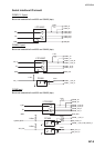
$GPRMC, hhmmss.ss, A, llll.ll, a, yyyyy.yy, a, x.x, x.x, ddmmyy, x.x, a, a, a *hh<CR><LF>
1 2 3 4 5 6 7 8 9 10
11 12 13
1. UTC of position fix (000000 - 235959)
2. Status (A=data valid, V=navigation receiver warning)
3. Latitude (0.0000 - 9000.0000)
4. N/S
5. Longitude (0.0000 - 18000.0000)
6. E/W
7. Speed over ground, knots (0.0 - 9999.9)
8. Course over ground, degrees true (0.0 - 359.0)
9. Date (010100 - 311299)
10. Magnetic variation, degrees E/W (0.0 - 180.0/NULL)
11. E/W
12. Mode indicator
(A=Autonomous D=Differential E=Estimated (dead reckoning) mode
F=Float RTK M=Manual input mode N=No fix P=Precise R=Real time kinematic
S=Simulator mode)
13. Navigational status indication
(S=Safe C=Caution U=Unsafe V=Navigational status not valid, equipment is not providing
navigational status indication
$--ROT,x.x,A*hh<CR><LF>
1 2
1. Rate of turn, deg/min, "-"=bow turns to port (-9999.9 - 9999.9)
2. Status: A=data valid, V=data invalid