


APPENDIX
AP-12
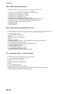
GBS - GNSS satellite fault detection
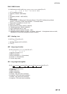
GGA - Global positioning system (GPS) fix data
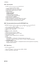
GLL - Geographic position - latitude/longitude
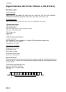
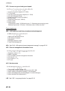
$**GBS, hhmmss.ss, x.x, x.x, x.x, xx, x.x, x.x, x.x h, h, *hh<CR><LF>
1 2 3 4 5 6 7 8 9 10
1. UTC time of GGA or GNS fix associated with this sentence
2. Expected error in latitude (0.0 - 999.9)
3. Expected error in longitude (0.0 - 999.9)
4. Expected error in altitude (no use)
5. ID number of most likely failed satellite (no use)
6. Probability of missed detection for most likely failed satellite (no use)
7. Estimate of bias in meters on most likely failed satellite (no use)
8. Standard deviation of bias estimate (no use)
9. GNSS system ID
10 GNSS signal ID
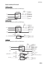
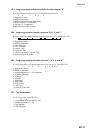
$**GGA, hhmmss.ss, llll.ll, a, yyyyy.yy, a, x, xx, x.x, x.x, M, x.x, M, x.x, xxxx,*hh<CR><LF>
1 2 3 4 5 6 7 8 9 10 11 12 13 14
1. UTC of position (no use)
2. Latitude (0.00000 - 9000.00000)
3. N/S
4. Longitude (0.00000 - 18000.00000)
5. E/W
6. GPS quality indicator
7. Number of satellites in use,00-12, may be different from the number in view (no use)
8. Horizontal dilution of precision (no use)
9. Antenna altitude above/below mean sea level (geoid) (no use)
10. Units of antenna altitude, m (no use)
11. Geoidal separation (no use)
12. Units of geoidal separation, m (no use)
13. Age of differential GPS data (no use)
14. Differential reference station ID, 0000-1023 (no use)
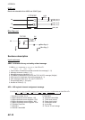
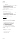
$**GLL,llll.lll,a,yyyyy.yy,a,hhmmss.ss,a,x,*hh<CR><LF>
1 2 3 4 5 6 7
1. Latitude (0.00000 - 9000.00000)
2. N/S
3. Longitude (0.00000 - 18000.00000)
4. E/W
5. UTC of position (no use)
6. Status (A=data valid V=data invalid)
7. Mode indicator (A=Autonomous D=Differential E=Estimated (dead reckoning)
M=Manual input S=Simulator N=Data not valid)