


v
The main features are
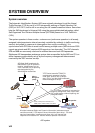
• Safety of navigation by automatically exchanging navigational data between ships and
between ship and coast
• Static data:
- MMSI (Maritime Mobile Service Identity)
- IMO number (where available)
- Call sign & name
- Length and beam
- Type of ship
- Location of position-fixing antenna on the ship
• Dynamic data:
- Ship’s position with accuracy indication and integrity status
- Universal Time Coordinated (UTC)
- Course over ground (COG)
- Speed over ground (SOG)
- Heading
- Rate of turn (ROT) where available
• Voyage-related data
- Ship’s draught
- Navigation status (manual input)
- Hazardous cargo (type)
- Destination and ETA (at master’s discretion)
• Short safety-related messages, free messages
• LCD panel satisfies the IMO minimum requirements plus simple plotting modes
• Interfaces for radar, ECDIS, PC for future networking expansion
• GPS/VHF combined antenna for easy installation available
• CPA/TCPA alarm
• Built-in GPS receiver for UTC synchronization and backup position-fixing device
• The Inland AIS feature is based on CCNR (Vessel Tracking and Tracing Standard for
Inland Navigation). Inland AIS receives and sends SOLAS AIS information, and
interfaces automatic data input such as blue sign, draught (in centimeters), air draught
(height from waterline), hazardous cargo blue cone indication, euro ship identifier and
inland ship type. Further, the inland AIS sends ETA (Estimated Time of Arrival) to lock,
bridge, terminal, etc. and displays response as RTA (Requested Time of Arrival) from
the lock, bridge or terminal. Information receivable from land stations include EMMA
warning, water level data, etc.