


2. RADAR, CHART RADAR OPERATION
2-38
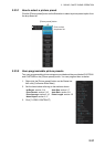
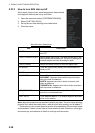
2.27.3 How to turn NAV data on/off
Wind, depth, ocean current, water temperature, date and time
and waypoint data may be set up as follows:
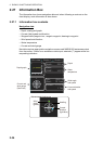
1. Open the menu then select [4 INFORMATION BOX].
2. Select [2 SET NAV DATA].
3. Set up the nav data referring to the table below.
4. Close the menu.
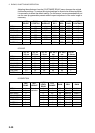
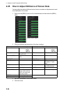
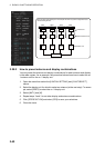
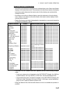
Nav data menu description
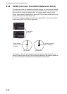
Note: Appropriate sensors are required to display any data. The wind vector shows a
direction from which the wind blows in, relative to own ship heading, and is labeled "T
*." Wind velocity is a true wind speed as a result of compensating for own ship's speed
and orientation. Ocean current (tide) is shown relative to bow in head-up, cursor gyro
and course-up, and reference to North in north-up and true motion.
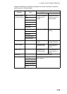
Item Description
1 DEPTH Selects unit of depth measurement, or turn depth indica-
tion OFF.
2 DEPTH GRAPH SCALE Selects depth scale range. The depth for the last 30 min-
utes is plotted with a yellow line. The [AUTO] setting auto-
matically adjusts the scale according to depth.
3 DEPTH MARK Selects the depth at which to show the depth mark.
4 CURRENT Turns the current (tide) display ON (current relative to
North) or OFF.
5 WIND Selects the unit of wind speed measurement.
6 WIND STAB Selects Wind vector format, among three choices:
APPARENT: Apparent wind measured by wind meter,
with ship's bow as reference.
NORTH: Apparent wind minus ship's movement, with
North as reference
THEORETICAL: Apparent wind minus ship's movement,
with ship's bow as reference.
7 TEMPERATURE Turns water temperature indication ON or OFF and se-
lects the unit of measurement.
8 WPT DATA Turns waypoint data OFF, or selects waypoint data refer-
ence, true or relative.