


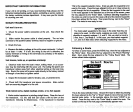
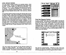
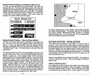
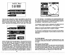

HOW LORAN-C WORKS
The Loran
system
consists of three to six transmitter stations. These
are called a "chain."
The letter "M"
designates
the master station inside
the chain.
The other stations in the chain are the secondaries. Their
names
are
V, W, X, Y,
and
Z,
although
not all chains have five second-
ary
stations. The
secondary
transmitters are
synchronized
with
the
master which transmits at
precise
time intervals. This time
interval is
called the
Group Repetition
Interval
(GRI).
Each chain has a different
GRI.
The
secondary
stations transmit at
precise
time intervals after the mas-
ter station transmits.
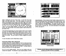
Since these transmitters are located hundreds of
miles
apart,
it takes
a different time for the
signals
from each transmitter
to
reach
you.
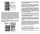
The Loran receiver measures this time difference be-
tween
the master and two of the secondaries. The Z-9500
automatically
chooses the best
master-secondary pairs
for
your
location.
The time
difference or
(TD)
is measured in micro-seconds.
Plotting
the
TD on a
chart with Loran-C lines results with
your position
somewhere
on a line
of
position (LOP).
A line of
position
is an
imaginary
line on which the
time
delay
between the master and one of the secondaries is the
same.
In this
example
the boat is located somewhere
on the 14605.2 Line Of
Position.
The Loran receiver then measures the time difference
between the
master
and another
secondary.
The
example
on the next
page
is
31882.8.
If
you plot
this LOP on a
chart,
you'll
notice that it crosses the
first
line-of-position.
Your
position
is at the intersection of the two lines.
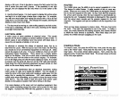
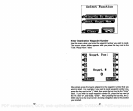
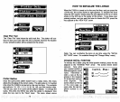
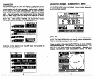
WAYPT * 2
_____________ LIJAYPT * 3
LIJAYPT * 4
_____________
WAYPT * 5
WAYPT * 6
____________
WAYPT * 7
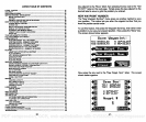
Enter New
Waypoint
Position
To save a
waypoint
other
than
your present position,
first
press
the
Waypoint
Save
key.
The
waypoint
save menu
appears.
Now
press
the
key
next to the "More" label.
Finally, press
the
key
next to the "New
Waypt.
Pos." label. A new menu
appears.
If
you
wish to save the
waypoint using latitude/longitude, press
the
key adjacent
to the "ENTER
LAT/LONG" label. To save a
waypoint using
TD's,
press
the
key
adiacent
to the "Enter TO's" label. The
steps
to save a
waypoint
are
identical. For this
example,
we'll use the
latitude/longitude
method. The
screen shown below
appears.
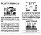
Now enter the
waypoint
location. Remember to add a zero to the
longitude
if ft's less than 100
degrees.
The screen shown at the
top
of
the next
page appears
after the last
longitude
number is entered.
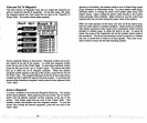
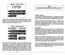
Save
Upt
Euiter
J
Uaypt
11 1
TDI. :40965.60
TD2 :85920.22
N 32°O0.45'
Id 83°11.33'
Down
Erase
Clear I
Uaypt Lat/Long
N
——°
u———0
II
1)
JC
lean
56
81
PDF compression, OCR, web-optimization with CVISION's PdfCompressor