


tion.
This is the most automatic initialization format. It
requires only
the
appears.To
select a
radius, simply press
the
key adjacent
to the
up
or
entry
of the
present position
from the
operator.
You don't have to know
which stations
are
best
or the
CR1
to use the initial
position only startup.
However,
when
the
Z-9500
is
in
the
automatic
mode,
it can
change
stations
at
any
time if it decides one or more stations are better to use
than others. This can result in small
position
inaccuracies. For ex-
ample, suppose you
use the bran one
day
and save a
waypoint.
The
next
day you
decide to
navigate
to that
waypoint.
If the Z-9500 uses
a
different set of stations on the second
day
than the ones used
on the
first,
you
could end
up
at a location that is a small distance
away
from
the desired
one. You can avoid
this
by switching
the Z-9500 into the
manual mode
after
it
has locked on to the stations in
the
chain and has
both
a
good
fix and shows a
position. Using
the manual mode forces
the unit
to use the ones it is
currently using
or ones
you
choose.
(See
the Manual
Station Selection section for more
information.)
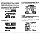
GRI ONLY
INITIALIZATION
This method
of
starting
the Z-9500
requires
the most
thought
from the
user. Not
only
will
you
need to select
the best SRI to use for
your
area,
but
you
will also have to choose the stations for the Z-9500 to use.
Using
the SRI
only
method forces the Z-9500 into the manual mode.
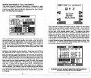
PRESENT POSITION AND GRI INITIALIZATION
Giving
the Z-9500 both
your present position
and the SRI
typically
lets it
find the stations faster.
Therefore,
it can
give you
a
position
faster
using
this initialization
procedure.
However,
you may
need to select
stations,
since the unit could start in the manual mode.
The reason for this is there are areas of the world that are covered
by
more than one CR1. One of the GRIs is better to use than the others
(depending
on
your location),
due to
crossing angles
and
signal
strengths.
If the SRI
you
enter
happens
to be the
preferred
SRI for
your
location,
the Z-9500 will switch to automatic and choose the sta-
tions to
use. If the SRI is not
preferred,
then the unit
will
switch to
the
manual mode and
you
will have to choose the stations. Based
upon
the
SRI used,
you
can
always
switch the Z-9500 into the manual
mode,
but
you
can't
always
use automatic.
Maps
of most ioran
coverage
areas are listed
in
the back
of this manual
to
help you
choose a CR1.
Many
of the
maps
show the
preferred
stations to use within the SRI for different locations. Use these stations
when
initializing
the Z-9500 for the best results.
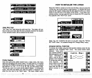
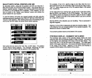
down arrows in the "PLOTTER RADIUS" menu until the desired radius
shows. Then
press
the
key
next to the "Clear label.
The Z-9500wi11
return to the
plotter
with the new radius.
Plotter
Update
Interval
The
plotter
shows
your
track
by drawing
a solid line behind
your present
position.
When the unit is turned on for the
very
first
time,
the
position
is
updated
once
every
ten seconds. You can
vary
this time from 2 sec-
onds to 20 minutes.
As each dot is
placed
on the track
line,
one is erased
from
the
end after
a certain
length
has been achieved. This shortens the
plotted
line,
but
still shows the
history
of
your passage.
If
you plot
a course that's a
long
distance
away
and use a short
update
time,
the line
may
not reach from
the
starting
location to the destination.
To
keep
a continuous line
plotted, you may
want to
experiment
with the
update
interval.
Lengthening
the interval between
plots gives you
a
better chance to see more
history.
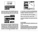
To
change
the
plotter
time,
first
press
the MENU
key
while the
plotter
is
displayed.
Next,
press
the
key
adjacent
to the "More" label on the
plotter
menu screen.
To select an
update
interval,
simply press
the
key
adjacent
to the
up
or down
arrows in the "UPDATE INTERVAL" menu.
When the desired time
appears
in the
menu,
press
the
key
next to the
"Clear" label. The screen will
clear,
returning
to the
plotter
with the new
time. The available times are:
2, 5, 10, 20,
and 30 seconds and
1, 2, 5,
10,
and 20 minutes.
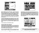
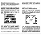
WAYPOINT
NAVIGATION
HOW TO SAVE A WAYPOINT
Waypoints
are locations that
you
save in the Z-9500's
memory.
You
can then
navigate
to these
positions using
the Steer
Indicator, Naviga-
tion,
or Plotter screens.
Waypoints
are useful
for
marking
shipwrecks,
hot
fishing spots,
and other
fishing
or
navigational
locations.
The Z-
9500 can store
up
to 75
waypoints.
You can store
your present position
as a
waypoint,
or enter TD's or
latitude/longitude positions.
58 79
PDF compression, OCR, web-optimization with CVISION's PdfCompressor