


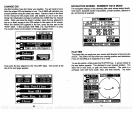
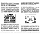

AUTOMATIC and MANUAL MODES
"PHI"
appear.
RALT
appear
if
the
unit is in the alternate mode. Fix
The Z-9500's Loran has both automatic and manual modes. This
means the unit will select the stations to use when it's in automatic. You
must select the stations when ifs in the manual mode.
The Z-9500 chooses the stations with the best
crossing angles
and
signal strengths
when it's in the automatic mode. It does this
by
continually monitoring
the stations
signals
to determine the best ones to
use.
If
the unit determines one or more stations are better to use than
the current
ones,
it will
automatically
switch to the new stations.
However,
there are times when
you
don't want the unit to switch sta-
tions. When
you're navigating using waypoints
is one. You must use
the same stations when
travelling
to a
waypoint
as the ones used when
the
waypoint
was saved. For
example,
if the
bran
was
using M,X,
and
Y when the
waypoint
was
saved,
you
must use
M,X,
and V to
navigate
back to that
waypoint.
Otherwise,
navigation
errors can occur.
Placing
the unit
in
the manual mode
keeps
the Z-9500 from
changing
stations.
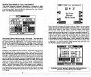
quality
is a measure of the lines of
position's crossing angles.
If the I ix
quality
is
poor,
use the
displayed
information with caution. The dis-
played position
can and will
vary
with
poor crossing angles.
The
posi-
tion
display
flashes the last known
latitude/longitude position
when the
fix
quality
is not usable. A number to the
right
of the
fix
quality message
shows the fix
quality's
value. It's
range
is from zero
(0)
to nine
(9),
with
zero the worst and nine the best.
Remember,
do not use the loran for
navigation
when the
position
display
flashes! Find and correct the
problem
before
navigating
with
the unit.
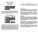
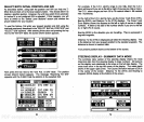
To
place
the Z-9500 in the manual
mode,
simply press
the AUTO
key.
The word
"MAN"
appears
at the bottom of the
position
screen,
showing
which mode is in use.
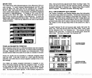
Although you
can switch from automatic to manual at
any
time,
you
cani
always
switch to automatic. The Z-9500 must be
using
the
pre-
ferred GRI for
yoUr
area in order to use the automatic mode. If
you try
switching
from manual to automatic while a
non-preferred
GRI is in
use,
the Z-9500
will
simply
switch back to the manual mode.
(A preferred
GRI is
one the Z-9500 determines is the best one to use based on
your
location.)
If
you
are in a location that is
covered
by multiple
GRI5,
you
won't
know which one is the
preferred
one.
However,
if the Z-9500
won't let
you
switch into
automatic,
you
can be certain that
you're
not
using
the
preferred
GRI.
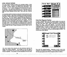
PRIMARY and
ALTERNATE
SOLUTIONS
The bran
normally
determines its
position by measuring
the time differ-
ence between the master and two other
secondary
stations. Each time
difference results in a line of
position.
Your
present position
is the
intersection of the lines of
position.
This is called a "fix".
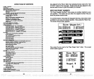
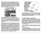
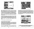
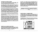
POSITION DISPLAY
-
SUMMARY MODE
The
position display
in the
summary
data mode is shown below. The
water
depth
shows at the
top
of the screen.
Immediately
below this is
your present position
in both
latitude/longitude
and time differences
(TO's).
The TD's shown are the ones used
by
the Z-9500 to
calculate
the
latitude/longitude.
The
message
box at the bottom of the screen shows
pertinent
mes-
sages
when
necessary.
For
example,
the cross track error
message
appears
:"STEER >" when
you
move to the left of course.
PRESENT POSITION
N
32° 0002'
W 800 00.12'
V
Z
:
:
45359.73
60866.14
MESSAGE BOX
l']tal:l
5'JFT
68
71
PDF compression, OCR, web-optimization with CVISION's PdfCompressor