


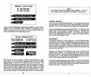
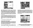
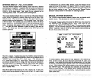

CHANGE GRI
Use this function if
you
don't know
your position.
You will need to
know
both the
proper
SRI and stations to use. The Z-9500 will calculate
your
present position using
the chain
you
select. See the charts
in the back
of this manual for the
proper
chain and stations to use
in
your
area.
Using
this initialization
procedure
switches the Z-9500
into the manual
mode. Once
you
know the chain's
number,
press
the
key adjacent
to
the
up
or down arrows in the SRI section
in
the center
of the screen.
When the desired SRI
appears
in
the
box, press
the
key
next to the
"Enter" label. In
this
example,
SRI
7980,
U.S. SOUTHEAST is used.
The screen shown at the bottom of this
page appears
next.
Now
press
the
key adjacent
to the
top
of the next
page appears.
"Use SRI" label. The screen at the
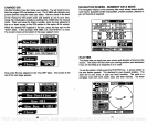
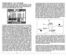
NAVIGATION
SCREEN
-
SUMMARY
DATA MODE
The
navigation display
in the
summary
data
mode shows bottom
depth,
route
name, waypoint
number and
position,
present position,
distance to
go,
and
bearing
to
waypoint.
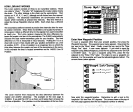
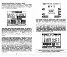
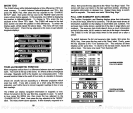
PLOTTER
The
plotter
lets
you easily
see
your
course and direction of travel
on the
screen. The
plotter
will also show
your starting position
and
destination
if
you
are
travelling
to a
waypoint
or on a route.
To use the
plotter,
simply press
the PLOTTER
key.
A screen similar to
the one below
appears.
The diamond is
your
present position.
The
solid
line is
your track,
or
path you
have
travelled. The circle is a
compass
rose
with
north, south, east,
and
west marked. The water
I
I
62
75
I.-al:l
49FT
I
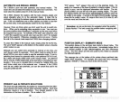
POSITION
S
F.:ECOIIEIENDED OR I
— HONE
7980
U.S. SOUTHEAST
I
POSITION
[IC. [IIj. IJIj'
ll U°OO. 00'
Use Position
Use CIII
Use Pos. & CR!
C
I
PDF compression, OCR, web-optimization with CVISION's PdfCompressor