


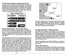
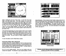
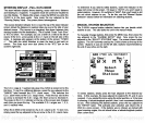

This screen shows all
navigation
information to a
waypoint
in
digital
numbers. To
display
this
screen,
press
the MENU
key
while the Z-9500
is in the loran mode. Now
press
the
key adjacent
to the "Nay.
Display"
label. The
following
screen
appears.
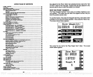
NO ROUTE
PRESENT
POSITION Ui
YPT.
*
1
N 32°O0.16'
Ui_8O0OO.18
I
(MG SR'Thlfl
I
4 STEER
I
I
HEADING WJBI
Water
depth
(Depth)
shows at the
top
of the screen. The route
name,
waypoint
number,
and
waypoint position
are shown on the left side of
the screen beneath the
depth display.
Your
present position
is shown to
the
right
of the
waypoint
information boxes.
Heading,
Cross Track Error
(XTE),
Time To Go
(TTG), Bearing
to
waypoint (BAG),
Ground
Speed
(SPD),
and
Velocity
Made
Good
(VMG)
show on the lower half
of the
display.
Heading
is the direction
you
are
travelling.
Cross track error
(XTE)
is
the distance to the left or
right
of
your
course. Time to
go (TTG)
is the
time it will take
you
to reach the
waypoint,
based on
your
current
speed.
Bearing
to
waypoint (BAG)
is the direction
you
must travel to reach
your
waypoint.
Ground
Speed (SPD)
is the
averaged speed
over
ground
that
you
are
making.
For
example,
if
you
are
travelling directly against
a two
knot current and
your
boat
speedometer
reads 10
knots,
your actually
speed
over
gnund
is
eight
knots. The SPD
display
is calculated from
loran data. It doesn't use the
optional speed
sensor to determine boat
speed.
Velocity
made
good (VMG)
is the
speed you
are
making
to-
wards a
waypoint.
For
example,
if
you
are
travelling
at ten knots
directly
at a
waypoint
and there's no current or
wind,
then
you
VMG is ten knots.
If
you
are
moving
180
degrees away
from the
waypoint,
then
your
VMG
is -10 knots.
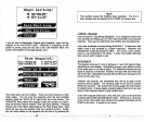
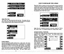
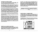
00000.00 CYC ERR 11
It.
—
V. .
—
Ufl 14598.83 CYC ERR 33
X:31883.31 SEARCH 9
:4536O.95
CYC ERR 29
:6O866.12
SEARCH '9
MfdI
FIX QUALITY
lfl1
tS
F.I*1
MODE
SOLN
(0 )
74
63
NAVIGATION SCREEN
-
FULL DATA MODE
GE!
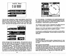
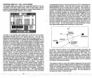
: 7980 U.S. SOUTHEAST
Iil]-al:I 4TFT
C
N 32°U0.15'
UI 80°OU.15'
IIIVZ
Select
Three
Stat ions
!i1I
0.01MM
j'101HM
P
•1II
0:00:19
ri
277°M
uai
3.1KM
iear
E titer
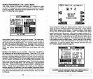
Since
using
the
"Change
GAl" feature
puts
the Z-9500 into the manual
mode,
you
have to select the stations used in the chain. Arrows with the
station
letters
appear
on this screen. To select a
station,
simply press
the
key
next to the desired station's letter. The stations
you
select
appear
near the
top
of the screen.
In
the above
example,
stations
M, V.
and Z were selected. When
you're
finished,
press
the
key
next to the
"ENTEA" label. If
you simply press
the CLEAA
key,
the Z-9500 returns
to the screen at the
top
of
page
62. The Z-9500
automatically
switches
to the
position
screen as shown below. Once it locks on to the
stations,
it
should show the
proper latitude/longitude
on the
position display
after
a short time. To view the station's
signal strength
and other
data,
see
the "Position
Display"
section on
page
70.
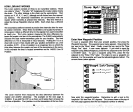
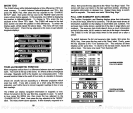
GRI :7930 I']*Jl:l 52FT
ri-
's.
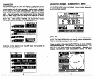
WARNING: DO NOT NAVIGATE WHEN THE POSITION DISPLAY
(EIThER
tAT/LONG OR
TD'S)
IS FLASHING!
PDF compression, OCR, web-optimization with CVISION's PdfCompressor